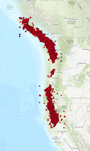
 Tectonic tremor epicenters Aug. 30, 2012 - Nov. 17, 2012 along the West Coast of the United States. Tectonic tremor epicenters Aug. 30, 2012 - Nov. 17, 2012 along the West Coast of the United States. There is a lot of speculation among people out there that reported tectonic tremor epicenters on the PNSN tremor map are actually showing earthquake epicenters and that these events are actually earthquakes. This is not true and in this post I will show you what the ETS epicenters are actually showing. Please click the title of this post or "read more" to continue...
3 Comments
 In this post I will briefly talk about a few events that occurred over the past few days. Nothing major occurred, but the activity was interesting nonetheless. Please click the title of this post or "read more" to continue...
 Sept. 13 swarm at Long Valley. Sept. 13 swarm at Long Valley. September has been a very active month for Long Valley Caldera. Starting on September 13, a fairly intense period of seismicity started primarily around the eastern section of Mammoth Lakes, which resides in the SSW section of Long Valley Caldera. The magnitudes were not large, not surpassing M3.0, but the quantity of events were substantial in the short period of time they occurred.
Please CLICK HERE to see some information about recent swarming at Long Valley Caldera. This post was originally posted to the "Quake Swarms" blog. 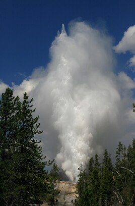 By Bpnjensen - Own work, CC BY-SA 4.0, https://commons.wikimedia.org/w/index.php?curid=72122121 By Bpnjensen - Own work, CC BY-SA 4.0, https://commons.wikimedia.org/w/index.php?curid=72122121 In this post I will show a few things. First, I will detail information about Steamboat Geyser, where it is located, and how each eruption's seismic signatures are composed of surface vibrations. Secondly, I will show how you can monitor for and predict Steamboat eruptions yourself.
Please click the title of this post or "read more" to continue... 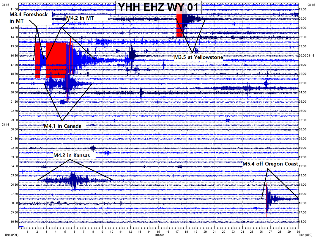 On August 15, 2019 at 19:46UTC, a M3.5 earthquake struck the southern border of Yellowstone National Park. This was the start of a 20 hour period of increasing seismicity for the United States and Canada. It was the largest earthquake to strike Yellowstone in just over 2 years and was detected on seismic stations hundreds of miles away.
During this time frame, about 4 1/2 hours after the M3.5 at Yellowstone, a M4.2 struck Manhattan, Montana, including multiple foreshocks leading up to the M4.2. Almost 2 1/2 hours later, a strange M4.1 struck in an odd location in Southeast Saskatchewan, Canada. Then, about 10 1/2 hours later, a strong M4.2 struck South Hutchinson, Kansas. Finally, the seismicity calmed after a M5.4 struck off the coast of Oregon along the Blanco Fracture Zone, approximately 2 hours and 23 minutes after the M4.2 in Kansas. All of these events can be seen on the helicorder above, which is from station YHH at Yellowstone. So, what caused this apparent increase in seismicity? North America was somewhat calm prior to this, except for the occasional M3 or so in California. Were all of these just a coincidence? It is up to you, seeing I do not have the answer for that. I will, however, show some data pertaining to these seismic events. Please click the title of this post or "read more" to continue... 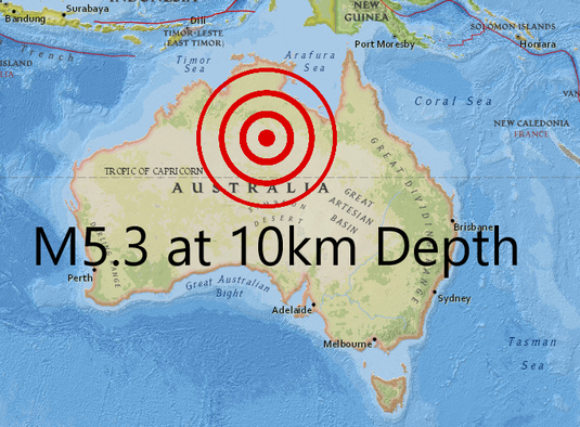 On August 1, 2019 at 01:22UTC, a M5.3 (M5.4) struck Northern Australia at 10km in depth. In this post, I will show you why I think this earthquake was very strange. For the magnitude and depth, I am using the determination from Geoscience Australia (basically the USGS of Australia). USGS only labels it as being 0.1 larger. Please click the title of this post or "read more" to continue...
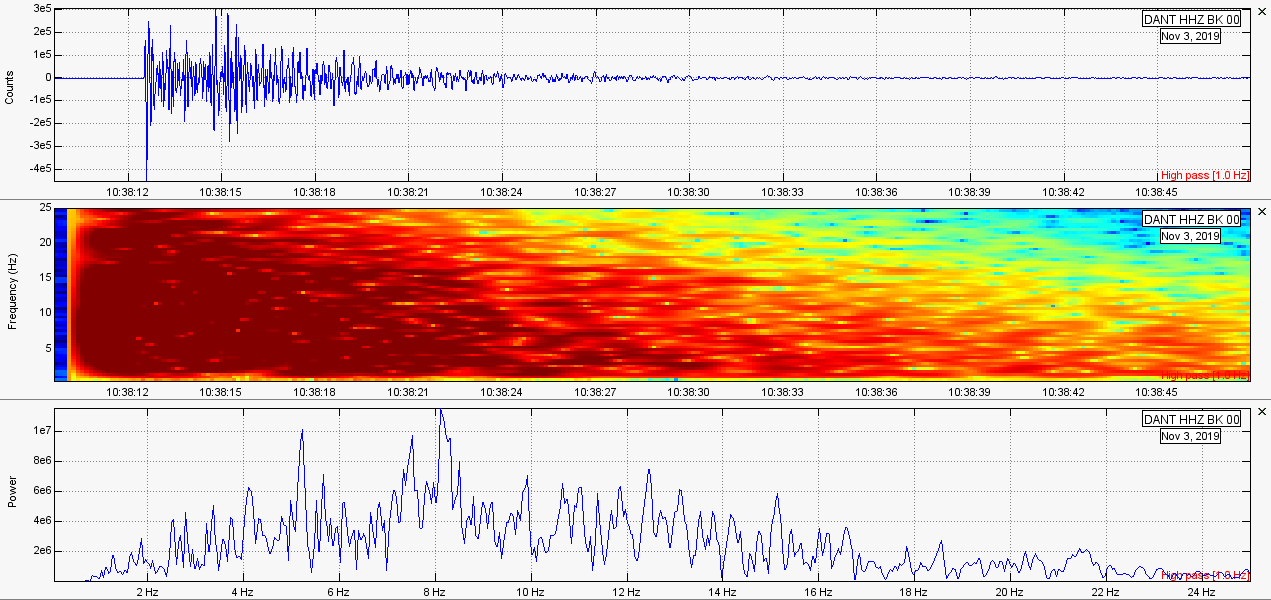
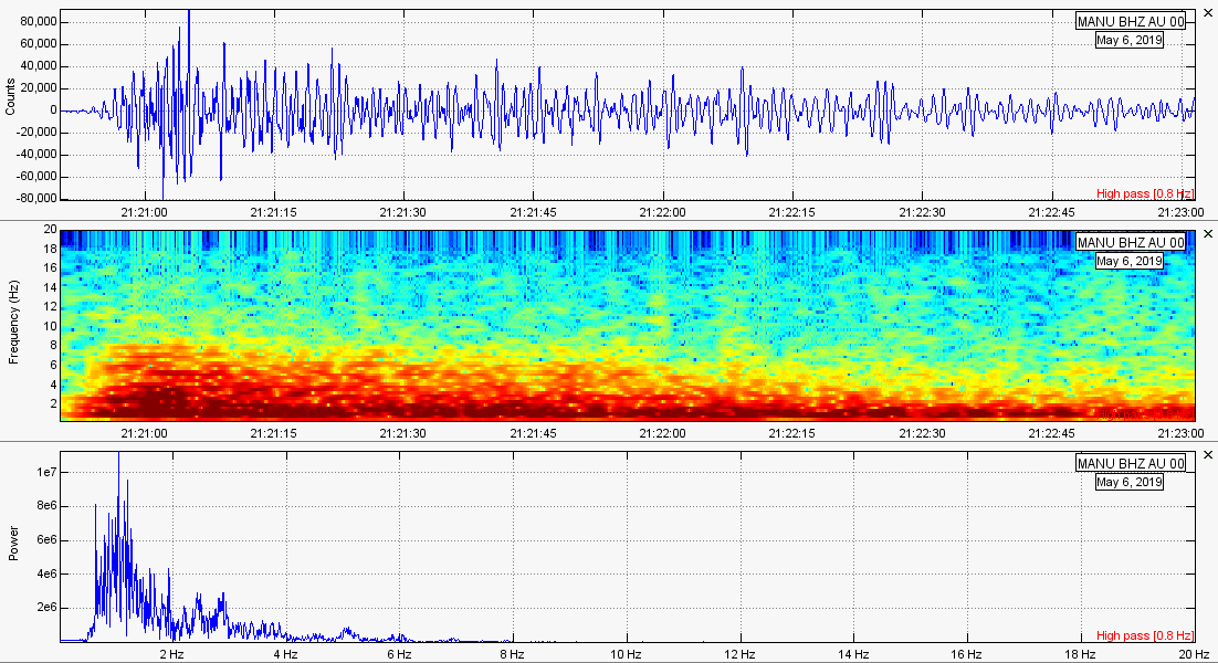
Hey guys. This is a very quick post which I originally made for my grandmother. My grandma loves all things about the Stromboli volcano in Italy. Eruptions are becoming larger and more frequent so I thought she would like a quick look at the type of activity I monitor and the way I monitor it.
In this post I have a video for you to watch. It shows 3 select Stromboli eruptions from Skyline Webcams. I sat down and recorded their live stream with a pen and paper on hand. I then recorded 3 select eruptions and the times they occurred. Then, I went to the closest seismic station I could find to see if I could correlate each eruption to a vibration detected on that same seismograph (seismometer). What I found was pretty cool! Each lava explosion generates some good sized seismic signals. 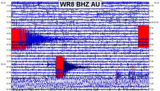 In this post, as usual, I will show some data and plots pertaining to the M5.3 and M4.4 in Australia, some micro-quakes along the New Madrid Seismic Zone, and the M6.6 off the coast of El Salvador in Central America. Seismic audio is included for the M6.6 and the two earthquakes that struck Australia. As usual, please click the title of this post or "read more" to continue...
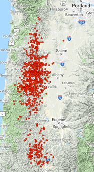 ETS from 5/16 through 5/18/2019 ETS from 5/16 through 5/18/2019 Although seismic activity is relatively low right now across the globe, there have been some interesting events the past day or so. Also, ETS (episodic tremor and slip) has been ongoing for a while now along the Oregon Coast. Well, just to the east of the coast. I will show some plots to these events. If you haven't already, please click the title of this post or "read more" to continue...
 Think most of what you see are surface events? Guess again! Think most of what you see are surface events? Guess again! HEADS UP: This post was meant to be on my Hawaii blog under the Seismic Events menu. Oh well!
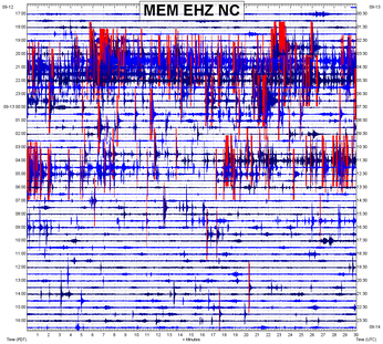
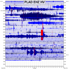
Well guys it has been a while since we have seen a true DLP-HFE (deep long period, high frequency event). I believe it occurred twice in the past week but today, May 15, 2019, these events returned with a vengeance! Over 9 of these strange deep seismic events struck between 37km and 46km in depth off the coast of Pahala, Hawaii, off the southern section of the Big Island of Hawaii. In this post I will show you my theory as to what is causing these events. I will also show a great deal of seismic plots as well. If you haven't already, click the title of this post or "read more" to continue... 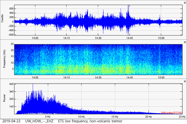 I am very excited I got the chance to analyze this stuff guys! So, the eastern section of the Olympic Peninsula in Washington State has been seeing a strange ETS (episodic tremor and slip) event as of the past few months. It seems to surge at times and is early. Usually it happens every 14 months, but it is early this time. Maybe this is just a precursor to a very large ETS that is predicted to begin in the next couple months at the maximum. Episodic tremor and slip is a phenomena only recently discovered in 2002. Low frequency, non-volcanic tremor has been detected many times by seismic stations in WA, OR, and even northern CA. Large slip of the plates has also been detected during increased tremor activity. The two are most definitely connected. Although not proven 100%, I theorize ETS does increase the chance of a large earthquake striking. If these ETS events were not occurring, however, Washington and Oregon would be seeing a great many M6 and M7 earthquakes. This slow-slip is caused by a lubrication of the plates during the ongoing subduction process of the Juan De Fuca plate under the North American plate. The purpose of this post is to show a few examples of what low frequency, non-volcanic tremor looks like. I also give you the ability to listen to what the tremor sounds like. Please click the title of this post or "read more" to continue...
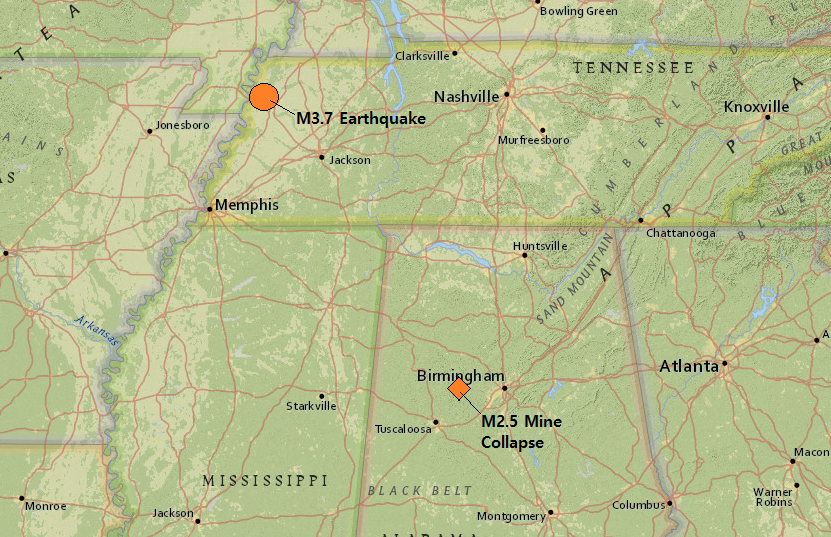 Hey guys! I am back. This is the first of two blog posts I am putting out today. The next one will be right above this one so don't forget to check it out as well! It will be showing some example of what low frequency, non-volcanic tremor looks like along the Olympic Peninsula in Washington State. However, in this post here I will show some quick data pertaining to the M3.7 in Tennessee which garnered well over 1,000 felt reports on earthquake.usgs.gov. Now although the distance is quite far, there was also a supposed mine collapse in Alabama which registered as a M2.5 earthquake. However as you can see in the image above, geologically-speaking they are not too far from each other. This mine collapse occurred around 3 hours prior to the M3.7 in Tennessee. Could they be connected? Maybe, maybe not. This post also contains seismic audio of these two events. If you haven't already, please click the title of this post or "read more" to continue...
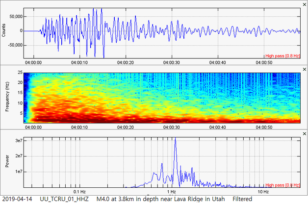 Hey guys! A very interesting earthquake has struck the Black Rock Desert Volcanic Field in Utah. I personally believe this M4.0 was a volcanic earthquake. Overall, you be the judge! I will show some information and data pertaining to this event and don't forget to try to analyze these events yourself! If you have not already, please click the title of this post or "read more" to continue...
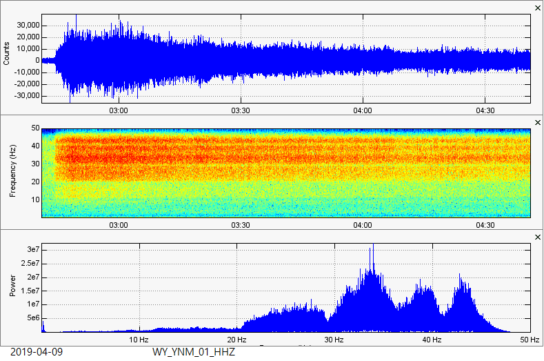 12th Steamboat Geyser eruption of 2019 (44th Steamboat Geyser eruption since early-2018). This was the largest Steamboat eruption of 2019 and the largest since around November 2018! Don't forget to check out my Steamboat pages under the "Seismic Events" dropdown menu! This is a quick post:
If you wish to see the topics above, please CLICK HERE to visit the video I made regarding them. Also, please CLICK HERE to visit some plots I made for the M3.0 that struck at 7.1km in depth off the coast of New York. |
AuthorBen Ferraiuolo is a fast learner and someone who will always stand for the truth. Visit "About Me" for more! Archives
November 2019
Categories |
 RSS Feed