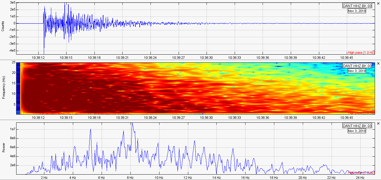
 In this post I will briefly talk about a few events that occurred over the past few days. Nothing major occurred, but the activity was interesting nonetheless. Please click the title of this post or "read more" to continue... Small Quakes Along the East Coast, USA 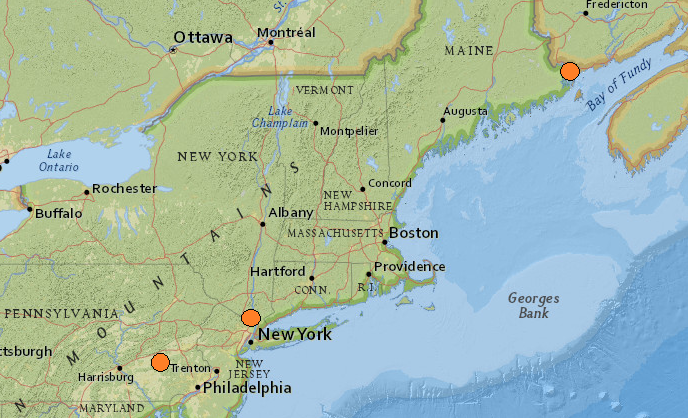 When people think of the East Coast of the USA they think about the beautiful skylines and the scenery of urban metropolises. Very rarely do people suspect that earthquake activity can occur on the East Coast. Regardless, the East Coast is no stranger to strong earthquakes. For example, on August 23, 2011, a strong M5.8 earthquake struck at 6.0km in depth not far from Washington D.C. This earthquake was a surprise and was felt many hundreds of miles away. This earthquake was the largest to strike the region since the 1886 M7.3 earthquake in South Carolina. Also, a M5.6 struck New Hampshire in 1940 and a M5.5 struck New York in 1944. However, most earthquakes as of late have been relatively small: mainly around M0.5 to M2.5. On November 4, 2019, between 03:51UTC and 21:49UTC, 3 earthquakes struck along the East Coast. The first was a M1.3 at 5.0km in depth under Spring Ridge, Pennsylvania. The USGS event page and plots are shown directly below. Take a look at how many people submitted a felt report to USGS that they felt this tiny earthquake. That is quite a substantial amount of people to report feeling a simple M1.3. The earthquake was also quite strong for how short it lasted: around 3 seconds or so for the main seismic waves. 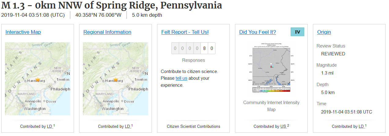 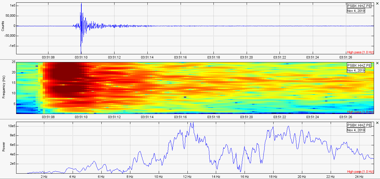 Then, at 20:52UTC, a M1.9 struck just off the eastern tip of Maine, technically within the Canadian border. This earthquake did not receive any felt reports even though it was supposedly strong than the M1.3 in Pennsylvania. Plots below are of the M1.9 (note the frequency range of the spectrogram was increased to 50Hz to show all recorded frequencies): 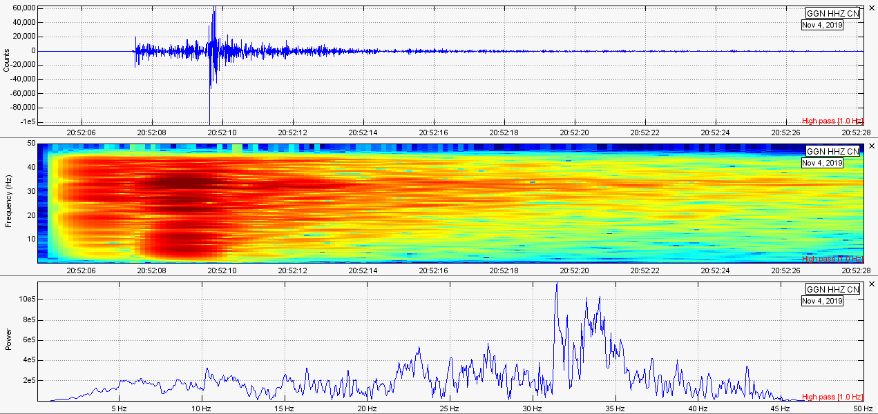 Then, at 21:48UTC, a M1.6 struck near Staten Island, New York at 2.4km in depth receiving only 1 felt report. Why was the weaker Pennsylvania earthquake felt much stronger than the actual stronger earthquakes during this day? Plots below are of the M1.6 in New York (note frequencies of the spectrogram reach 50Hz to show all frequencies recorded): 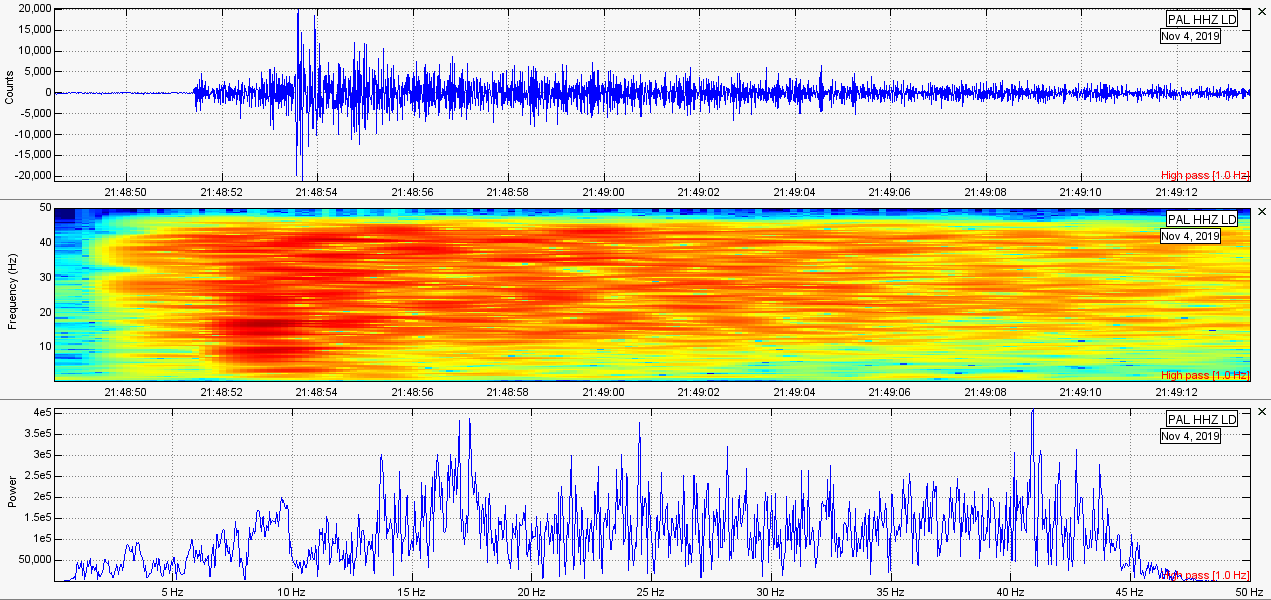 M2.0 near Glacier Peak Volcano, WA 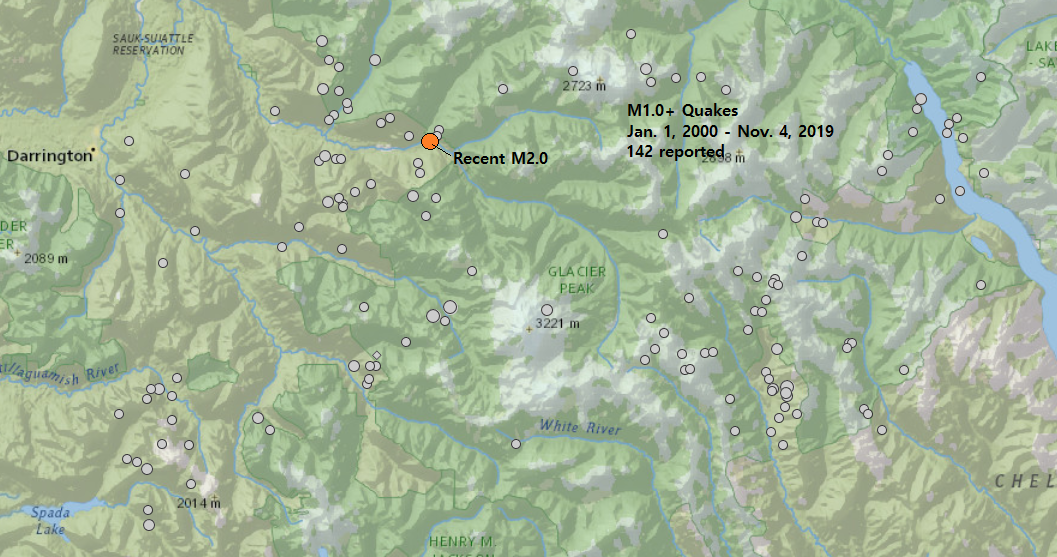 Glacier Peak stratovolcano is often overlooked as a potential threat. However, due to the type of magma it erupts, Glacier Peak is the only other volcano in Washington, other than Mt. St. Helens, that can produce massive tephra/ash eruptions. Despite its large eruptive history, the volcano thankfully slumbers to this day. Earthquakes rarely strike under the volcano edifice itself, but the area surrounding the volcano does see moderate earthquakes from time to time. As can be seen in the image above, there have only been 142 reported earthquakes M1.0 and above from Jan. 1, 2000 through Nov. 4, 2019 with only a single earthquake reportedly having occurred under the volcano itself. The largest earthquakes to strike this region were a M3.4 and M3.0 just under the western base of the volcano on Nov. 25, 2015 and a M3.3 for to the SE on March 17, 2008. The recent earthquake was a M2.0 at 7.5km in depth on Nov. 3, 2019 at 08:15UTC to the NW of the volcano. Although population is sparse at best around the volcano, this event did receive one felt report. Plots below are of this earthquake: 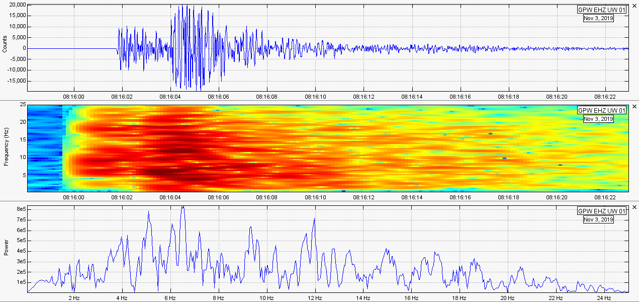 M3.1 SW of Lassen Peak, CA 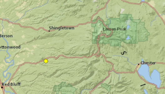 Lassen Peak, also known as Lassen Volcanic Center, last explosively erupted from 1915-1917 with events culminating in the year 1917. This volcanic eruption, the only other eruption to occur in the continental USA in the 20th century besides Mt. St. Helens, was the first eruption to be extensively photographed. A simple Google search will compile multiple images of the eruptive activity of Lassen Peak from 1915-1917. Although earthquake activity is common in this area, few earthquakes above M3.0 occur with only 11 earthquakes reported around this region since the beginning of 2005, the largest being a M3.9 just south of Lassen Volcanic Center on Nov. 11, 2014. On Nov. 3, 2019, at 10:38UTC, a M3.1 struck at 11.0km in depth about 20km or so SW of Lassen Volcanic Center. Only 7 people reported to USGS that they felt this event. Due to the distance from the volcano, and the singular and tectonic characteristics of this event, it is likely this is due to regional tectonics, rather than volcanic activity from Lassen. Regardless, we should always keep an eye out. Below is the event page from USGS for this event and the plots showing this event from the closest seismic station: 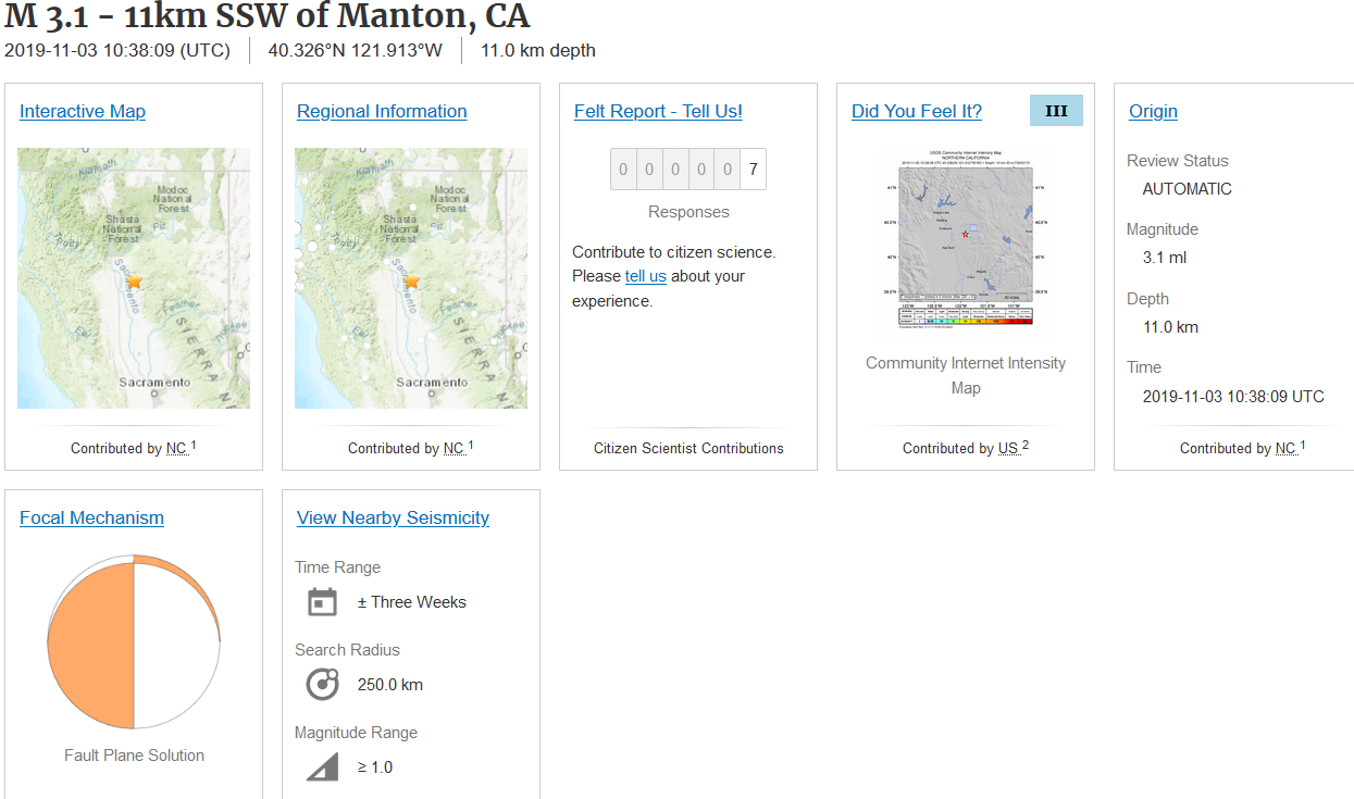 M4.2 near Clear Lake Volcanic Field, CA 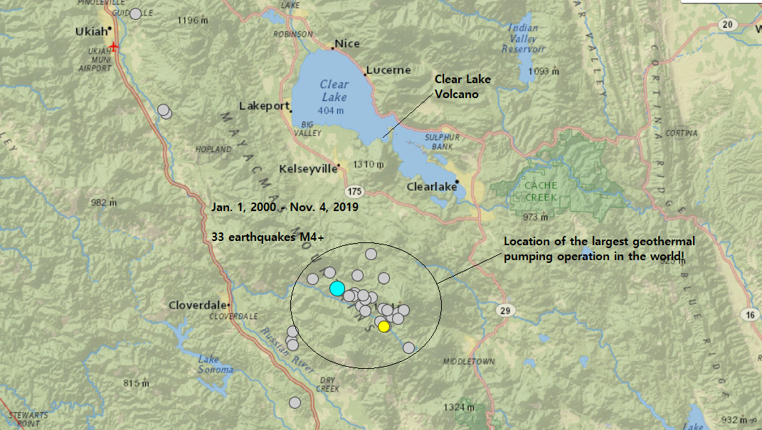 Clear Lake Volcanic Field hosts the largest geothermal energy operation in the world near its southern boundaries. This volcanic field has not experienced an eruption for quite some time, but is still very active and will likely erupt again in the future. The geothermal energy facility gathers heat to produce steam from a magma chamber around 4 miles beneath the surface and larger than 8 miles in diameter. Here is some quick info about Clear Lake Volcanic Field from USGS: "Clear Lake Volcanic Field is located about 90 miles north of San Francisco, California. The town of Clearlake lies within the volcanic field as does much of the 43,000-acre fresh water lake of its namesake. The Geysers steam field, which sits at the southwest margin of the volcanic region, is host to one of the world's most productive geothermal power plants, producing enough electricity for 850,000 homes. The heat driving the geothermal system emanates from a zone of partially molten rock (magma) deep below the greater Clear Lake volcanic system. The most prominent volcanic feature is 300,000 year-old Mount Konocti, rising about 975 m (3,200 ft) above the southwestern shore of the lake. The most recent eruptions occurred about 11,000 years ago around Mount Konocti. Although Clear Lake volcanic field has not erupted for several millennia, sporadic volcanic-type earthquakes do occur, and the numerous hot springs and volcanic gas seeps at in the area point to its potential to erupt again. Monitoring in the Clear Lake region by the USGS and a collaborative effort with Calpine Corporation in the Geysers Steam Field, provides real-time tracking of earthquake activity. In addition, the USGS periodically analyzes volcanic gases and hot springs in the region." As seen via the map image above, there have been 33 earthquakes at or larger than M4.0 around this area since Jan. 1, 2000. The large majority of seismicity occurs under the geothermal production facility. The largest since Jan. 1, 2000 was a M5.0 at 1.5km in depth on December 14, 2016 at 16:41UTC. On Nov. 3, 2019 at 20:34UTC, a M4.2 struck the geothermal pumping operation at 3.1km in depth. Below is the event page and plots of this event. 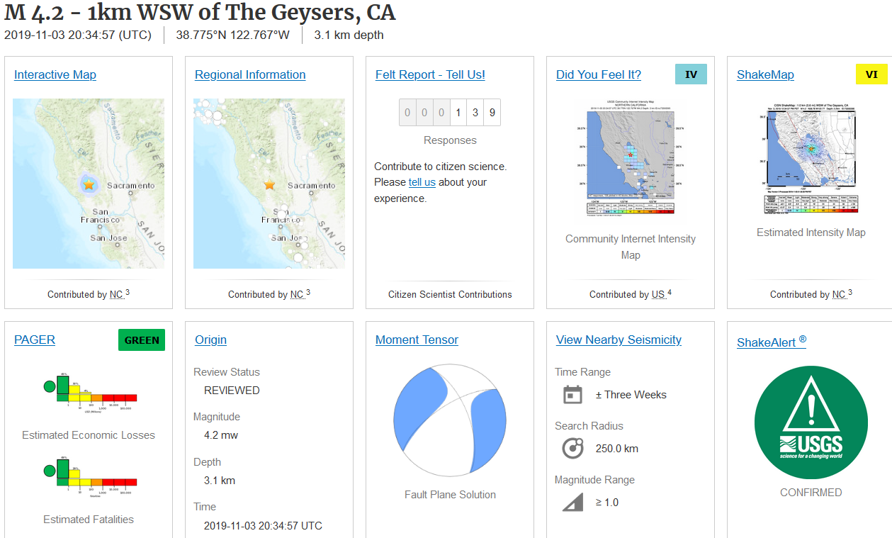 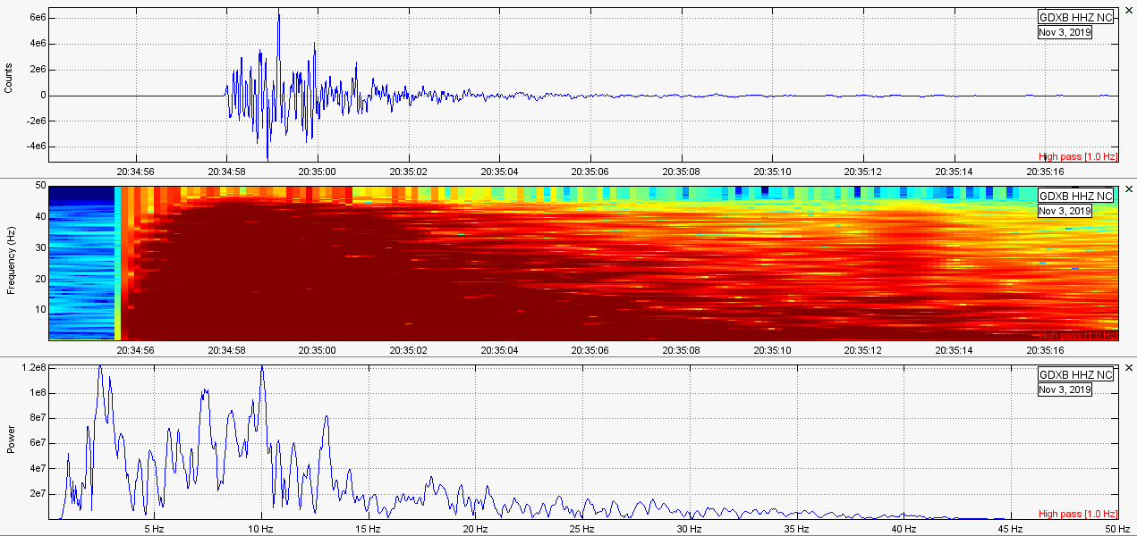
0 Comments
Leave a Reply. |
AuthorBen Ferraiuolo is a fast learner and someone who will always stand for the truth. Visit "About Me" for more! Archives
November 2019
Categories |
 RSS Feed