 In this post I am going to discuss and show the details of an extremely peculiar rapid-fire earthquake swarm that just recently struck north of Green River in southwest Wyoming. This earthquake swarm was a rapid fire swarm, kind of like the ones seen from time to time near West Thumb Lake and Yellowstone Lake at Yellowstone, and is one of the craziest and coolest swarms I have ever had the chance to analyze. However a big difference is that this swarm, with magnitudes reaching around 3.0-3.2, contained many low frequency earthquakes. Sometimes the low frequency events were happening in such close proximity that they blended to create a type of low frequency tremor, which is what volcanic tremor is theorized to be made of. It is highly peculiar this type of earthquake swarm, with these magnitudes and this amount of energy, would even dare to strike in SW Wyoming. This was for sure a strange one and this post will detail as much as possible. Please click the title of this post or "read more" to continue, if you have not done so already.
11 Comments
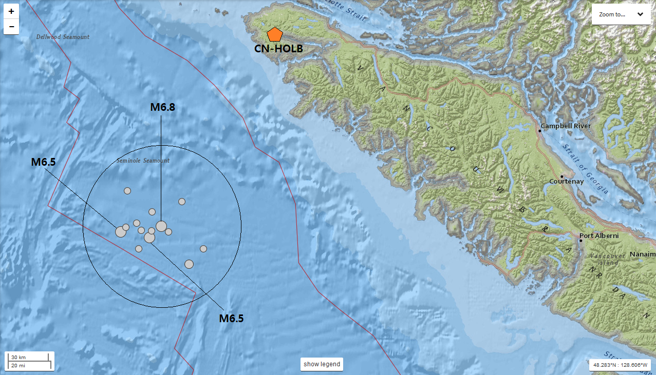 A map of the earthquake swarm. The circle details the likely earthquake swarm zone. The 3 largest earthquakes are labeled as well as one of the closest seismic stations to this swarm. Station HOLB in the CN network is what I will use for the plots below. During October 22-23, 2018, a large earthquake swarm struck off the northern tip of Vancouver Island. Actually, this swarm occurred extremely close to the epicenter of the smaller swarm that struck on February 13-14, 2019. This swarm I will talk about in this post contained many M4's, some M5's, and 3 earthquakes above M6.0. The 3 earthquakes above M6.0 were reported as M6.5, M6.8, and another M6.5 just after the 6.8. Sadly, the depths were not constrained on any of these earthquakes so all of the earthquakes have a depth set to 10.0km in depth. Obviously it is impossible all of the 14 events occurred exactly at that depth, so it is sad that we cannot add that part of the analysis into the equation. Also, this is likely the largest earthquake swarm this area has seen. Although, as seen below, many M6.0 and above earthquakes have struck since the early-1900s, this has the highest concentration and magnitude of any other swarm in this location since the early-1900s. I could be wrong, but that is what it is looking like! In this post I detail much of the swarm via seismic images and plots. If you haven't already, please click the title of this post or "read more" to continue.
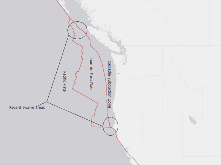 During late February 13th into the 14th, a strange earthquake swarm appeared under the northern section of the Cascadia Subduction Zone, off the coast of the northern tip of Vancouver Island. It is interesting to note, as seen in the image above, that some swarming has been occurring off and on both near the northern and southern ends of the Cascadia Subduction Zone. The largest earthquake of the Feb. 13-14, 2019 swarm off Vancouver Island was first reported to be a magnitude 4.8, later upgraded to a magnitude 5.3. Although only 2 earthquakes were reported, which is too small to be considered a swarm, there were at least 28 other earthquake events I was able to detect using P wave cross correlation and studying the characteristics of the events themselves. To continue this post, please click the title or "read more" if you have not done so already.
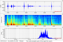
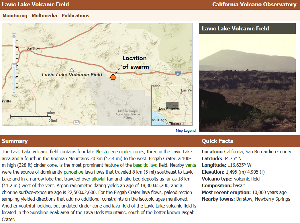 Welcome to the first post on another new page just recently added to my website! This first post will deal with a very energetic, rapid fire swarm that struck east of Los Angeles on February 7, 2019. This swarm seems to be similar to the ones seen at West Thumb Lake in Yellowstone from time to time (CLICK HERE for that). This swarm also occurred very close to Lavic Volcanic Field and the Pisgah Cinder Cone. As usual, please click the title of this post or "read more" to continue...
|
About
This blog page is solely for interesting earthquake swarms that occur in locations other than the ones I already have posted. Pretty much any earthquake swarm I am interested in, that cannot be placed on other pages, will be placed here. Please click the title of each post or "read more" to view each swarm. Archives
October 2019
Categories |
 RSS Feed