BEN FERRAIUOLO
  • Home
  • Yellowstone
    • Yellowstone Blog
    • 2008-2009 Yellowstone Lake Dike Intrusion
    • Rapid-Fire Swarms 2014-2018
    • Steamboat Geyser Eruptions >
      • Steamboat Eruptions 2020
      • Steamboat Eruptions 2019
      • Steamboat Eruptions 2018
  • Hawaii
    • Hawaii Blog
    • Hawaii Spasmodic Tremor
    • 2018 Kilauea-LERZ Eruptions
  • How To...
    • ...Retrieve Seismic Data
    • ...read webicorders/helicorders and seismic plots
    • ...Understand Spectrograms
    • ...USE SWARM Software
    • ...use jamaseis program
    • ...use waves program
    • ...understand UTC
    • ...Read/Create GPS Deformation Charts
    • ...use s.w.a.r.m. program (OLD)
  • Seismic Events
    • Event Examples
    • Exotic Events
    • Whale Calls
    • Cascade Volcanoes' Low Frequency Events
  • Seismo-Blog
  • Other Seismic Blogs
    • Quake Swarms
    • United States
    • East Coast, USA
    • World
  • Monthly Volcano Updates
  • Uplift/Subsidence Update
  • Videos/Multimedia
    • Newberry Videos
    • (OLD) 2019 Monthly/Yearly Updates
  • Seismic Software
    • jAmaSeis
    • SWARM
    • WAVES
  • Seismic Network Help
  • Links
  • About Me
  • Contact
  • Test Your Knowledge!
  • Lucas Andrew Ferraiuolo (Pro Pics)
  • Garbage Trucks?!

Yellowstone Caldera, WY

Jan. 6, 2019 Swarm NNE of Yellowstone Lake

1/6/2019

0 Comments

 
Picture
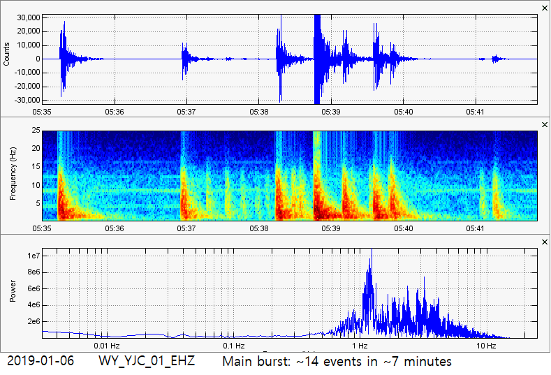
The main sequence of the January 6, 2019 swarm just south of Amethyst Mountain just barely outside of the Yellowstone Caldera rim, NNE of Yellowstone Lake. If you wish to see most of the data pertaining to this strange swarm, then please click the title of this post or "read more" to continue.
Directly above are the helicorders of this swarm from 10 of the closest seismic stations.

From 5:29UTC to 5:46UTC, January 6, 2019 (10:29pm to 10:46pm Mountain Time, January 5, 2019), a large magnitude swarm broke out just NNE of Yellowstone Lake (striking just a couple miles south of Amethyst Mountain). The largest reported event was a magnitude 2.8 at 8.8km in depth and a M2.8 at 6.9km in depth, but I believe the deeper M2.8 earthquake was more likely to be a M3.3. So far, 8 earthquakes have been reported which is not too bad considering there were ~15 events for the whole swarm.

Using the program WAVES, along with data acquired from multiple surrounding stations, there were ~15 earthquakes within that 17-minute time frame. Remember whenever you see "~", that means "approximate" or "about". Most of the seismicity occurred around M1.5-M2.8, within ~7 minutes. The location of this swarm, shown below, was an extremely odd location for a swarm. This was another rapid fire swarm but, to the best of my knowledge, rapid fire swarms of this magnitude or quantity have never struck this area.

Below are the seismic plots and some brief information on this event. Remember to always pay attention to chart labels first, especially when dealing with separate plots. That is because the time period for each different 3-plot image is slightly different than the others (at times). Remember, if you keep the size of a chart the same, but increase the amount of data shown within that chart, it will show less and less detail. Also pay attention to any captions beneath any images. All images were generated by myself using data obtained from IRIS or USGS, using the program SWARM and WAVES.

Picture
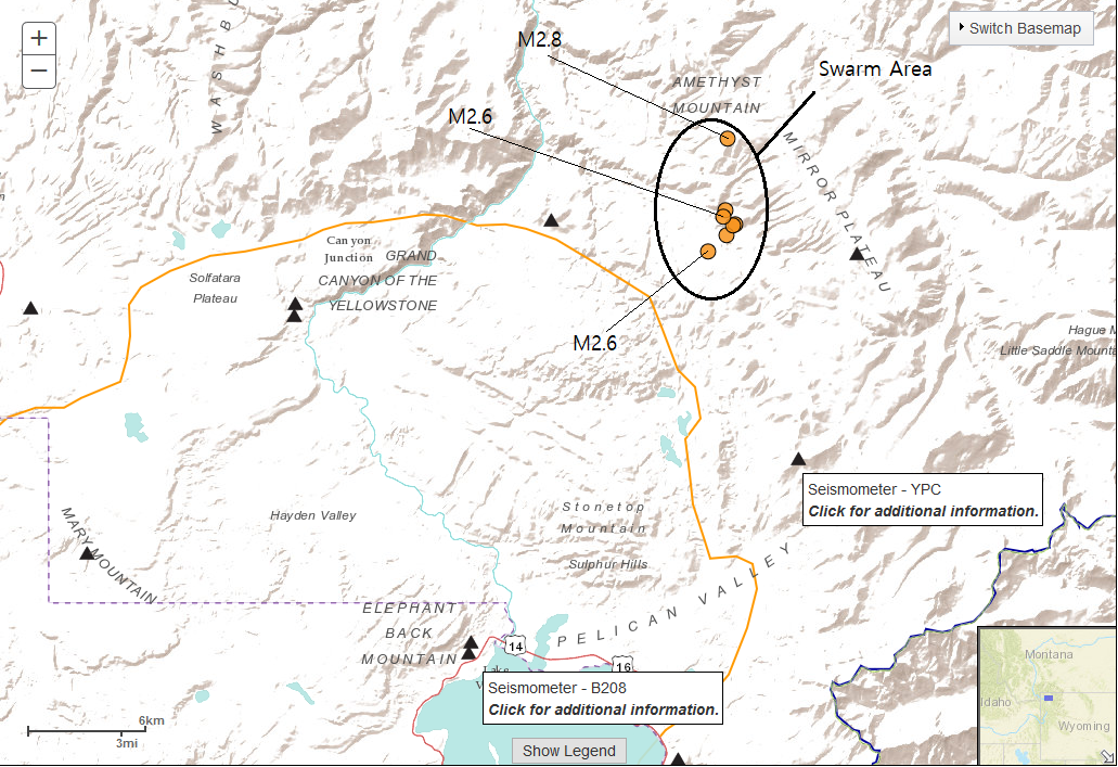
The swarm area for the Jan. 6, 2019 sequence. According to the most recent analysis, the swarm moved towards the southwest while shallowing at the same time. What was trying to escape??? Let me know what you think!
Picture
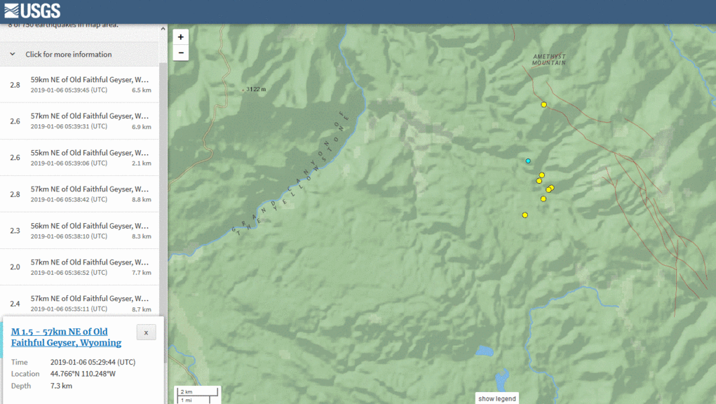
The progression of the swarm. Starts with the M1.5. Notice how by the end of the swarm, the depths are more shallow.

Seismic Plots

Waveforms (via WAVES)

If you wish to see the video I made where I analyzed these events, please CLICK HERE or watch it below.
0 Comments


Leave a Reply.

    About

    Please click a post title to view the data pertaining to that event!

    This is the seismic events page for Yellowstone National Park and Caldera, which resides in northwest Wyoming. Yellowstone is an absolutely massive caldera super-volcano. It sits at a shocking perimeter of 34 by 45 miles (55 by 72km) and that is only the caldera boundary! A caldera is created when land immediately erupts and collapses, while the magma chamber almost completely empties, creating a crater imprint called a caldera. Some calderas around the world are small in comparison (i.e. Kilauea) to other calderas formed by super-volcanic eruptions (i.e. Yellowstone in Wyoming or Long Valley in California).  Yellowstone is theorized to contain a magma chamber and a much deeper, much larger magma reservoir just beneath the chamber. This two-chamber system is also theorized to be caused by a "magma plume". Magma plumes are thought to draw their eruptive ability from deep within our planet, possibly from our lower mantle. That is why volcanoes caused by magma plumes are much more dangerous and far more unpredictable than their counterparts that are caused by normal tectonic forces. Yes, many volcanoes are caused by tectonic forces as one plate attempts to breach or dip beneath another one. A perfect example of this is the Cascade Range on the West Coast of the United States. Many volcanoes in the world are caused by this but some, the more unpredicatble ones, are caused by magma plumes.

    Remember to always pay attention to all chart labels! All images were generated by myself using the IRIS DMC seismic archive and the FREE seismic program S.W.A.R.M.

    Archives

    February 2020
    December 2019
    August 2019
    July 2019
    June 2019
    May 2019
    March 2019
    February 2019
    January 2019

    Categories

    All

    RSS Feed

Home

Hawaii Blog

Yellowstone Blog

Steamboat Geyser 2019

DISCLAIMER: There are currently problems with some images not showing or images being the incorrect ones. If you see this problem, please notify me. I am attempting to resolve this issue.
Copyright © 2019
  • Home
  • Yellowstone
    • Yellowstone Blog
    • 2008-2009 Yellowstone Lake Dike Intrusion
    • Rapid-Fire Swarms 2014-2018
    • Steamboat Geyser Eruptions >
      • Steamboat Eruptions 2020
      • Steamboat Eruptions 2019
      • Steamboat Eruptions 2018
  • Hawaii
    • Hawaii Blog
    • Hawaii Spasmodic Tremor
    • 2018 Kilauea-LERZ Eruptions
  • How To...
    • ...Retrieve Seismic Data
    • ...read webicorders/helicorders and seismic plots
    • ...Understand Spectrograms
    • ...USE SWARM Software
    • ...use jamaseis program
    • ...use waves program
    • ...understand UTC
    • ...Read/Create GPS Deformation Charts
    • ...use s.w.a.r.m. program (OLD)
  • Seismic Events
    • Event Examples
    • Exotic Events
    • Whale Calls
    • Cascade Volcanoes' Low Frequency Events
  • Seismo-Blog
  • Other Seismic Blogs
    • Quake Swarms
    • United States
    • East Coast, USA
    • World
  • Monthly Volcano Updates
  • Uplift/Subsidence Update
  • Videos/Multimedia
    • Newberry Videos
    • (OLD) 2019 Monthly/Yearly Updates
  • Seismic Software
    • jAmaSeis
    • SWARM
    • WAVES
  • Seismic Network Help
  • Links
  • About Me
  • Contact
  • Test Your Knowledge!
  • Lucas Andrew Ferraiuolo (Pro Pics)
  • Garbage Trucks?!