BEN FERRAIUOLO
  • Home
  • Yellowstone
    • Yellowstone Blog
    • 2008-2009 Yellowstone Lake Dike Intrusion
    • Rapid-Fire Swarms 2014-2018
    • Steamboat Geyser Eruptions >
      • Steamboat Eruptions 2020
      • Steamboat Eruptions 2019
      • Steamboat Eruptions 2018
  • Hawaii
    • Hawaii Blog
    • Hawaii Spasmodic Tremor
    • 2018 Kilauea-LERZ Eruptions
  • How To...
    • ...Retrieve Seismic Data
    • ...read webicorders/helicorders and seismic plots
    • ...Understand Spectrograms
    • ...USE SWARM Software
    • ...use jamaseis program
    • ...use waves program
    • ...understand UTC
    • ...Read/Create GPS Deformation Charts
    • ...use s.w.a.r.m. program (OLD)
  • Seismic Events
    • Event Examples
    • Exotic Events
    • Whale Calls
    • Cascade Volcanoes' Low Frequency Events
  • Seismo-Blog
  • Other Seismic Blogs
    • Quake Swarms
    • United States
    • East Coast, USA
    • World
  • Monthly Volcano Updates
  • Uplift/Subsidence Update
  • Videos/Multimedia
    • Newberry Videos
    • (OLD) 2019 Monthly/Yearly Updates
  • Seismic Software
    • jAmaSeis
    • SWARM
    • WAVES
  • Seismic Network Help
  • Links
  • About Me
  • Contact
  • Test Your Knowledge!
  • Lucas Andrew Ferraiuolo (Pro Pics)
  • Garbage Trucks?!

Yellowstone Caldera, WY

Aug. 29, 2019 - Largest Rapid Fire Swarm since 2018 New Years Eve

8/30/2019

0 Comments

 
Picture
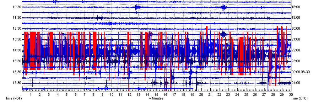
In the afternoon/evening of August 29, 2019, the strongest rapid-fire swarm to strike Yellowstone since late-2018 occurred. It was a typical strong rapid-fire swarm which struck along the East Mount Sheridan fault system.

The characteristics of this swarm are indicative of some type of magmatic fluid migration, likely hydrothermal fluids which do commonly transport up towards the surface. I will show the usual seismic plots and seismic audio to this earthquake swarm. 

Please click the title of this post or "read more" to continue...
Picture
USGS EQ Map
Yellowstone Station Map
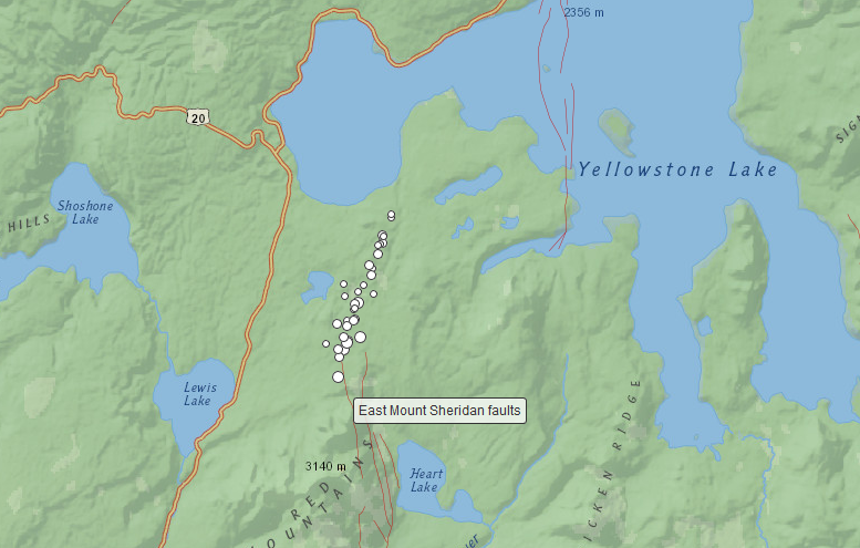
First off, please check out the USGS EQ map button above to view reported seismicity for this location and time period. You may also select the station map button to see all stations within Yellowstone National Park.

On August 29, 2019, a large rapid-fire swarm broke out south of West Thumb Lake and ENE of Lewis Lake. This earthquake swarm was the largest rapid-fire event within the Yellowstone National Park boundary since the December 31, 2018 earthquake swarm that struck NNW of the northern tip of Yellowstone Lake.

Over the past few months, seismicity has slowly been increasing around the northern section of the East Mount Sheridan fault system (pictured above). The recent rapid-fire swarms there have primarily been small. I believe it is possible this is related to magmatic fluid migration along the fault structure, from below to above it, therefore causing hundreds of micro-failures causing these earthquakes. Rapid-fire swarms like this are usually associated with fluid migration, especially at Yellowstone. Yellowstone has a very large and dynamic hydrothermal system so fluid migration such as this should occur periodically.

To see previous swarms like this one, please CLICK HERE to visit my page dedicated to rapid-fire swarms at Yellowstone from 2014-2018.

Below is some information about this swarm:

August 29, 2019 swarm:

Start of swarm: 21:20UTC
End of swarm: 22:45UTC (Total of 1 hour and 25 minutes.)

Info: A few micro-quakes occurred before and after the time period stated above. I am only dealing with the main earthquake swarm sequence for August 29 in relation to what plots and information I am posting. This swarm also occurred along the northern most section of the East Mount Sheridan fault system. It is possible this is related to magmatic fluid migration along the fault structure, therefore causing hundreds of micro-failures causing these earthquakes.

Total earthquake count (includes even the tiniest, unreported events): ~210 events of all sizes (Although many were very small, and some were not, so this count could be lower than the actual count. This is due to many of the events being so closely spaced that they appear to be one event.)

Reported count: 35 (more might be reported soon)
Largest reported earthquake of this swarm: M2.7 at 2.0km in depth
Largest amplitude: ~101,000 (PB_B944_--_EHZ), ~32,800 (WY_YLT_01_EHZ)
Closest active seismic station to swarm: B944 in the PB network
Severity: Moderate-Major short term rapid-fire swarm

Depth of swarm area: 1.4km through 9.4km in depth.

Below are helicorder plots from the 6 closest seismic stations to this swarm:
If you wish to see which earthquakes in the plots below were reported, simply go to one of the buttons I provided somewhere above that shows you the USGS earthquake map for Yellowstone during this time period. Earthquakes are reported in UTC and the times on the plots are in UTC as well. Also, I do not detail every single event of the swarm in the plots below. However, I do try to show most of them.

There are 38 images within the slideshow below.
Also, as usual, seismic audio of this earthquake swarm is below. The audio was taken from the seismic station used for the plots above. All seismic audio is best heard when it is sped up. Please use your headphones since it may be hard to hear with a computer speaker, but be wary of the volume! Every pop or crack you hear is an earthquake. Enjoy!
Picture
0 Comments


Leave a Reply.

    About

    Please click a post title to view the data pertaining to that event!

    This is the seismic events page for Yellowstone National Park and Caldera, which resides in northwest Wyoming. Yellowstone is an absolutely massive caldera super-volcano. It sits at a shocking perimeter of 34 by 45 miles (55 by 72km) and that is only the caldera boundary! A caldera is created when land immediately erupts and collapses, while the magma chamber almost completely empties, creating a crater imprint called a caldera. Some calderas around the world are small in comparison (i.e. Kilauea) to other calderas formed by super-volcanic eruptions (i.e. Yellowstone in Wyoming or Long Valley in California).  Yellowstone is theorized to contain a magma chamber and a much deeper, much larger magma reservoir just beneath the chamber. This two-chamber system is also theorized to be caused by a "magma plume". Magma plumes are thought to draw their eruptive ability from deep within our planet, possibly from our lower mantle. That is why volcanoes caused by magma plumes are much more dangerous and far more unpredictable than their counterparts that are caused by normal tectonic forces. Yes, many volcanoes are caused by tectonic forces as one plate attempts to breach or dip beneath another one. A perfect example of this is the Cascade Range on the West Coast of the United States. Many volcanoes in the world are caused by this but some, the more unpredicatble ones, are caused by magma plumes.

    Remember to always pay attention to all chart labels! All images were generated by myself using the IRIS DMC seismic archive and the FREE seismic program S.W.A.R.M.

    Archives

    February 2020
    December 2019
    August 2019
    July 2019
    June 2019
    May 2019
    March 2019
    February 2019
    January 2019

    Categories

    All

    RSS Feed

Home

Hawaii Blog

Yellowstone Blog

Steamboat Geyser 2019

DISCLAIMER: There are currently problems with some images not showing or images being the incorrect ones. If you see this problem, please notify me. I am attempting to resolve this issue.
Copyright © 2019
  • Home
  • Yellowstone
    • Yellowstone Blog
    • 2008-2009 Yellowstone Lake Dike Intrusion
    • Rapid-Fire Swarms 2014-2018
    • Steamboat Geyser Eruptions >
      • Steamboat Eruptions 2020
      • Steamboat Eruptions 2019
      • Steamboat Eruptions 2018
  • Hawaii
    • Hawaii Blog
    • Hawaii Spasmodic Tremor
    • 2018 Kilauea-LERZ Eruptions
  • How To...
    • ...Retrieve Seismic Data
    • ...read webicorders/helicorders and seismic plots
    • ...Understand Spectrograms
    • ...USE SWARM Software
    • ...use jamaseis program
    • ...use waves program
    • ...understand UTC
    • ...Read/Create GPS Deformation Charts
    • ...use s.w.a.r.m. program (OLD)
  • Seismic Events
    • Event Examples
    • Exotic Events
    • Whale Calls
    • Cascade Volcanoes' Low Frequency Events
  • Seismo-Blog
  • Other Seismic Blogs
    • Quake Swarms
    • United States
    • East Coast, USA
    • World
  • Monthly Volcano Updates
  • Uplift/Subsidence Update
  • Videos/Multimedia
    • Newberry Videos
    • (OLD) 2019 Monthly/Yearly Updates
  • Seismic Software
    • jAmaSeis
    • SWARM
    • WAVES
  • Seismic Network Help
  • Links
  • About Me
  • Contact
  • Test Your Knowledge!
  • Lucas Andrew Ferraiuolo (Pro Pics)
  • Garbage Trucks?!