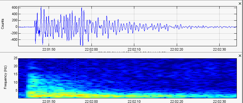
 September 24, 2018 Mt. Hood Event Seismogram/Spectrogram Analysis: UW_VLL_--_EHZ To start, if you have not seen the original article about the event I am going to be talking about then please CLICK HERE. This post here will not make much sense unless you read the original. On September 24, 2018 a very strange event occurred at Mt. Hood. It originally was listed as an earthquake. The earthquake in question was analyzed and its characteristics indicated a long period, low frequency earthquake possibly indicative of magmatically derived volcanic gas "farting" its way up to the surface. The earthquake occurred just 15 miles west of Mt. Hood's summit. It was very peculiar but there is now an update! This event has now been marked as an "explosion" by PNSN and USGS. The event type changed, but the depth changed from 5.3km in depth to 5.1km in depth. Only a 0.2km depth differential! How can an explosion occur at around 5km underground if related to quarry/mine activity? We will assess the data provided and you be the judge. It was a very odd event! Please click the title of this post or "read more". 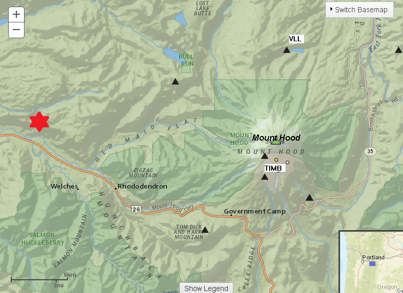 The picture directly above shows the location of the September 24, 2018 22:01UTC event just 15 miles west of the summit of Mt. Hood. This event was originally labeled as an earthquake for a couple days until I just noticed they changed it from an earthquake to an "explosion". To me, this event is very peculiar and in my opinion is not an explosion. In this post I will examine the new evidence and show an example of an actual quarry/mine blast compared to this event. 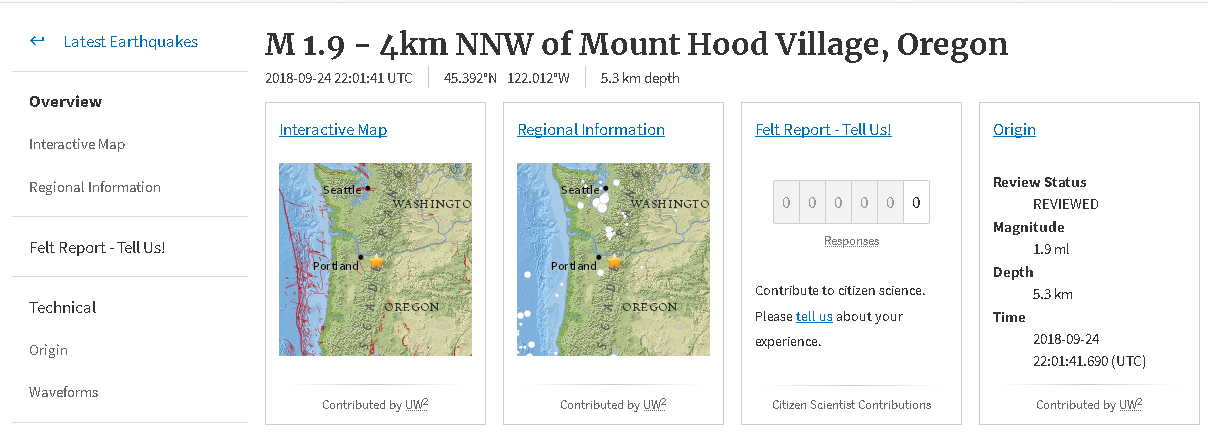 This image above shows the original earthquake details before it was changed to an "explosion". Please note that this was not an automatic report. Look where it says "review status" and note how it says "reviewed". If it said automatic, then that would mean the event was recorded only by a computer and needs to be reviewed by a seismologist. Once it is reviewed and confirmed by a seismologist, it will say "reviewed" as it does here. Notice it says M1.9 at 5.3km in depth? Well look at the image directly below of the updated event: 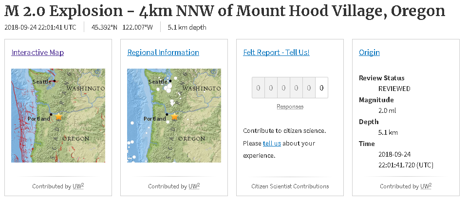 Notice the change? Apparently it was reviewed AGAIN by a seismologist and changed to a M2.0 explosion instead of the original M1.9 earthquake! But that is not the strangest thing. Notice how in the original earthquake info from USGS the confirmed depth was 5.3km? Well look at the new confirmed depth... 5.1km! The crazy thing about that is they only changed it by 0.2km (but reported quarry/mine explosions are always at a negative depth, indicating a surface event, so why was this NOT at a negative depth?). How is it possible for a quarry/mine explosion to occur that deep? I will get into that in a second. 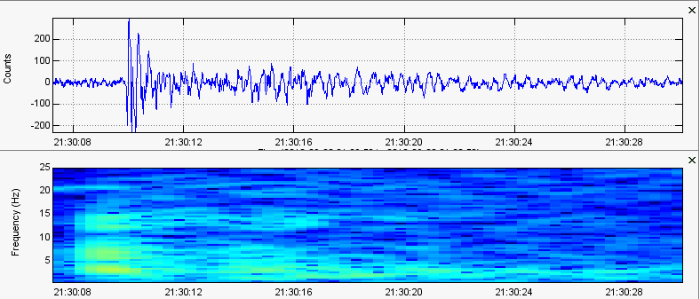 Known magnitude 2.0 quarry blast event in Granite Falls, WA on September 28, 2018 at 21:30UTC. Taken from seismic station BHW_UW_EHZ_-- which is 30km from the epicenter of this confirmed quarry/mine blast. 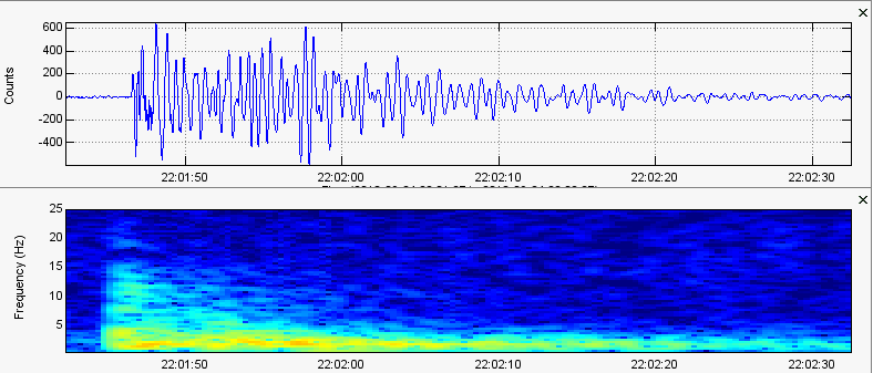 Seismogram/spectrogram analysis image of the strange magnitude 2.0 LF/LP event or explosion near Mt. Hood on September 24, 2018 at 22:01UTC. Taken from seismic station VLL which was 26.7km from the event. Let's real quick focus on the two images directly above (please read their captions). The first image is the seismogram/spectrogram analysis of a real confirmed quarry/mine blast in Granite Falls, WA. Now please compare that to the second image. The second image is the seismogram/spectrogram analysis of the strange long period low frequency earthquake (as I believe) or explosion (as PNSN states) that occurred 15 miles west of Mt Hood's summit. Both events are stated to carry the same exact magnitude as each other and both stations are about the same distance from their respective events. To start, please note the drastic time difference. The quarry blast lasted about 20 seconds or so. The Mt. Hood event, stated to carry the same magnitude as the Granite Falls quarry blast, lasted almost a whole minute! Also please compare their waveforms and frequencies. You can tell the odd event near Mt Hood is considered a low frequency event, but the quarry blast from Granite Falls cannot be placed into the same category. I personally believe the event near Mt Hood was not a quarry/mine blast. Why? Remember how the depth from the original report said 5.3km in depth but was changed to 5.1km in depth? PNSN states that it did occur around 5.1km in depth. They also state it was an explosion. How could that be? If an explosion occurred at 5.1km in depth, then that also works out to 3.1 miles! Again I say, how could this be? The image directly below shows the deepest mines in the world (WikiPedia): 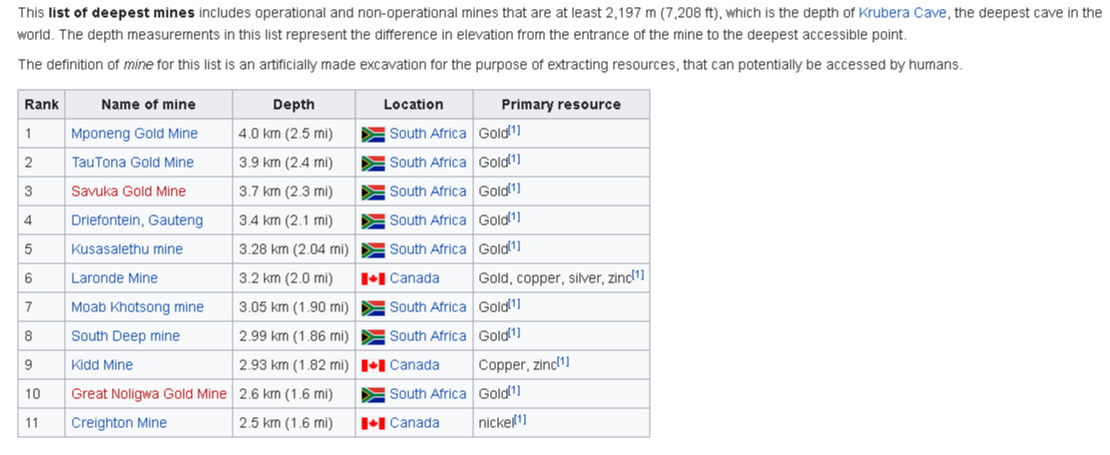 So it seems Mt. Hood, Oregon is not on the list. The deepest mine only comes in at 4.0km in depth (2.5mi)! Of course holes have been dug deeper than this, but the point is that there is no way a human-caused quarry/mine explosion can occur at 5.1km (3.1mi) in depth, in this area, just 15 miles west of Mt Hood's summit! That is extremely deep for an explosion so I am still labeling this September 24 Mt Hood event as an LF/LP event since the depth has been confirmed multiple times by seismologists. Maybe an explosion did occur underground... But it wasn't caused by humans, that is for sure! Again, maybe a volcanic gas event? Who knows. 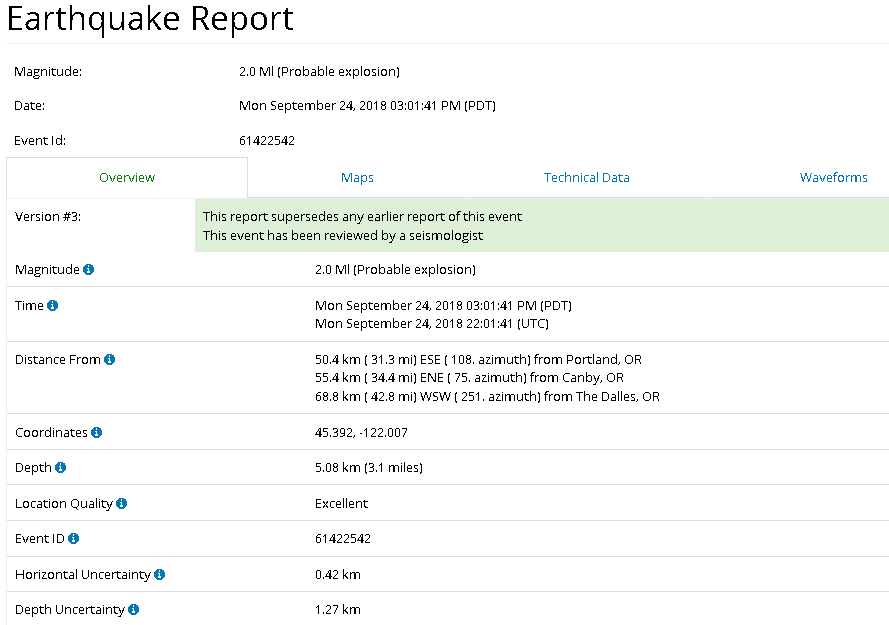 PNSN report for the September 24, 2018 Mt. Hood event. Event ID: 61422542 The image directly above is the seismic report for the low frequency event that occurred on September 24, 2018 22:01UTC 15 miles west of Mt Hood's summit. Note they still state it is a "probable explosion". Well, it resembles nothing like quarry/mine explosions I have seen before. And the confirmed depth just adds to the strangeness! They even note, next to "depth uncertainty", that there is only a +-1.27km leeway. Simply put, they know this "explosion" event occurred underground but the deepest mines in the world come far short of this depth! So what the hell is going on at Mt Hood? Please feel free to let me know! 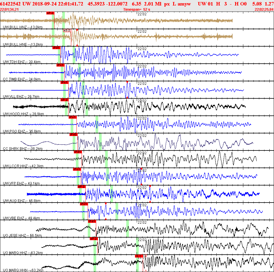 The image directly above is of the waveform (seismogram) analysis of the September 24 Mt Hood event. This was not compiled by me, but by PNSN. If you wish to view this for yourself, please CLICK HERE to goto the event page for this specific event. You then can click "waveforms" to see this. They compiled the waveforms of this event from 15 seismic stations. The closest being 13km away and the farthest being 63km away. The two green vertical highlights, for each seismogram, shows the probable P and S wave arrivals.
This event was for sure very odd! They still say it was an explosion, but who knows. This event occurred at about 3.1 miles in depth but the deepest accessible mine in the world is only 2.5 miles deep! Even if this was a human-caused event, I am pretty sure we would have heard about it. 3.1 miles is extremely deep! So I still prefer the cause was from volcanic gas escaping from Mt Hood's magma chamber, traveling through some unknown catalyst, and "popping" or "farting" when it finally reached a blocked area. That is just a theory and this does seem to be an isolated incident. If anything changes at Mt Hood you will be the first to know! Thank you for your time and have a great day!
0 Comments
Leave a Reply. |
AuthorBen Ferraiuolo is a fast learner and someone who will always stand for the truth. Visit "About Me" for more! Archives
November 2019
Categories |
 RSS Feed