Possible volcanic collapse off USA East Coast??? Also, M4.0 in Kansas and Steamboat Erupts Again...1/16/2019  Hey guys. Some pretty interesting seismicity has been occurring lately. First off, there was a M4.6 (originally M4.7) yesterday off the coast of Maryland. Now this is not too crazy but is pretty dang notable since we never really see that many events around this size, in this area. Now the characteristics of this event are much more interesting than the rarity of it. Does the data provided possibly indicate some of type of large collapse off the coast of Maryland? Remember I am not a professional so I do not know for sure. However the evidence is quite compelling. We will take a look at the data for that earthquake and also look at the data for the M4.0 in Kansas and the recent Steamboat Geyser eruption last night. As usual, please click the title of this post or "read more" to continue (if you are not already on this post)... M4.6 off the Coast of Maryland, USA 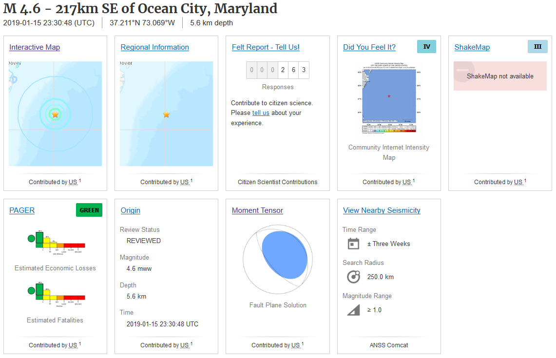 USGS event page as of 12:00pm PST, January 16, 2019.  Location of the M4.7 (downgraded to M4.6). At 23:30UTC January 15, 2019 (which is also 6:30pm Eastern Time, same date) a M4.6 earthquake struck at 5.6km in depth off the coast of Maryland. The first image above is the USGS event page (as of 12:00pm PST, January 16, 2019) for the M4.6 off the coast of Maryland. The second image you see is the location of the M4.6, which was downgraded from M4.7. This event is not super rare, but is definitely notable. As you will also see in a second, this event was quite peculiar in the way the energy was dispersed. I have created my own personal event page for this earthquake under "Seismic Events 2", "East Coast, USA". Please CLICK HERE if you wish to view that. It shows slightly more data than I will on this blog post here. Below is the 3-plot image I generated using SWARM and data obtained from IRIS for this M4.6 earthquake. Station S61A is the closest station to this event's location. 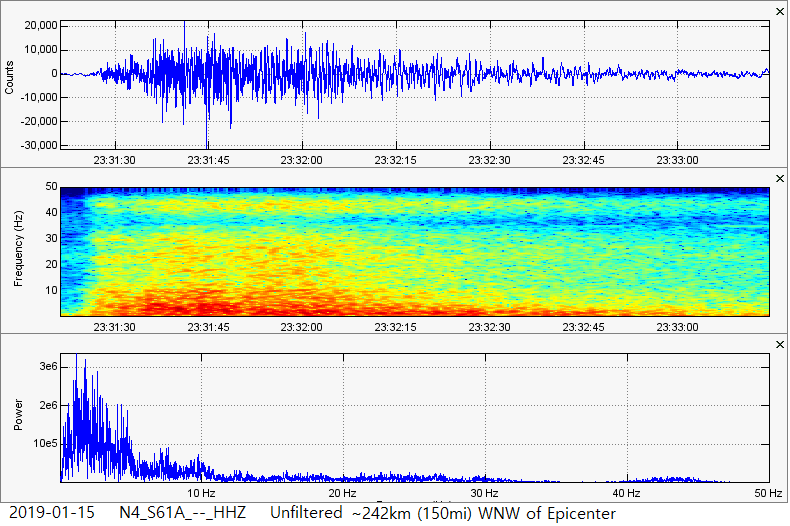 Notice the strange characteristics and the dominant frequencies below 5Hz? This was for sure a very interesting event. Also note the frequency range of the spectrogram is higher than what I usually set. To me, this event almost looked like some type of volcanic eruption or collapse. So I decided to do some digging. Below you will first see the moment tensor of one of the volcanic eruptions that occurred at Kilauea during the mid-2018 eruptions in Hawaii. Just a heads up, I am not the best at reading moment tensors. But I am getting better! Moment tensors can assist scientists in discovering in which way the energy was dispersed from any given event. They look very odd and are sometimes called "beachballs". I wanted to compare the moment tensor "beachball" from the Kilauea eruptions to the M4.6 that just occurred off the coast of Maryland. What I found is quite intriguing! 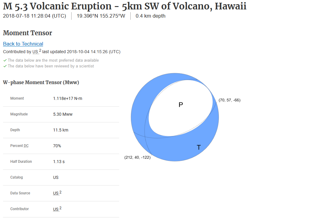 Notice how on the "beachball" above that it appears this volcanic eruption spread out its energy almost equally in all directions? Well check out the moment tensor for the M4.6, shown directly below. 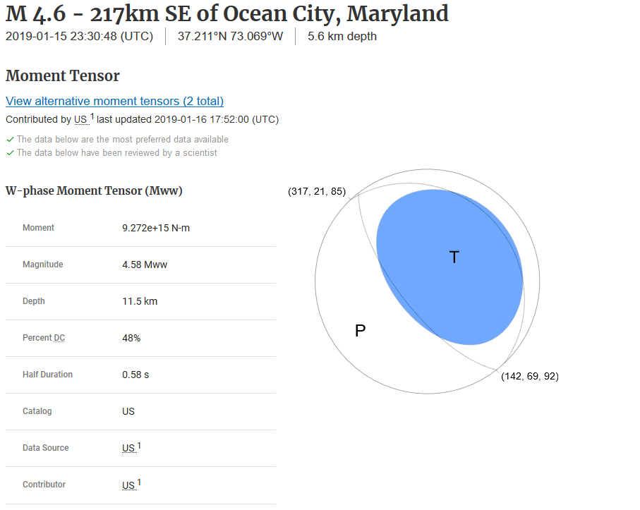 Notice how this moment tensor looks very similar to the one from the Kilauea eruption, but almost completely opposite? Instead of the energy spreading out in all directions, it almost looks like the energy collapsed in on itself. Could this indicate that this was not a normal tectonic event? Could this indicate that the M4.6 off the coast of Maryland was some type of collapse event? I wholeheartedly believe so. Remember though I am still learning how to read moment tensors. But from what I have seen, this does appear to be some type of collapse event. If so, was this volcanic in nature? That would be crazy, but not unprecedented. There are multiple sea mounts underwater near this area so historically there has been known to be volcanic activity. Or was there simply an underground cavern that was destabilizing over a long period of time and just decided to collapse? Regardless of the cause, this definitely seems like some type of collapse event. Pretty cool, huh? M4.0 in Kansas 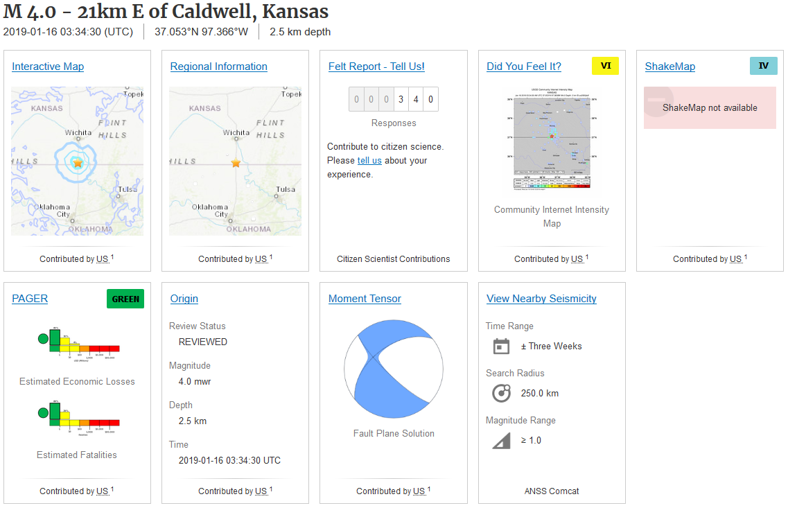  At 3:34UTC January 16, 2019 (which is also 8:34pm Mountain Time, January 15, 2019) a magnitude 4.0 earthquake struck at 2.5km in depth right under the Kansas/Oklahoma border. This area does see many earthquakes and they could be increasing due to increased waste-water injection (fracking). I personally believe that fracking can cause earthquakes and this idea really has been gaining momentum in recent years. The first image you see is the USGS event page for this M4.0. As of 12:00pm PST January 16, 2019, over 340 people felt this earthquake! Remember that is only the number of people who REPORTED feeling the event, not the actual number of people. This was a very interesting earthquake as was quite strong too! It was strong enough to be detected on seismic stations many hundreds of miles away, including the ones at Yellowstone (plot from MCID shown below). For the following seismic plots, please remember to always pay attention to chart labels and any captions beneath any images. 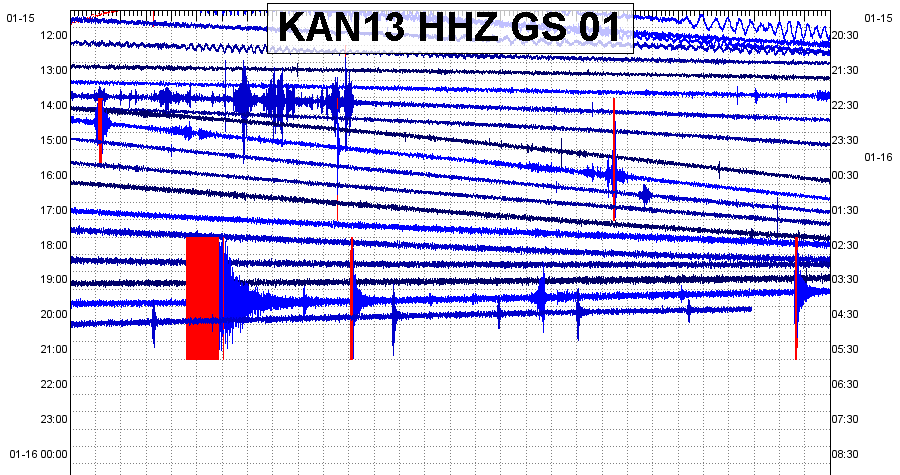 The helicorder generated from the closest seismic station to the M4.0 in Kansas. The largest earthquake you see is the M4.0. 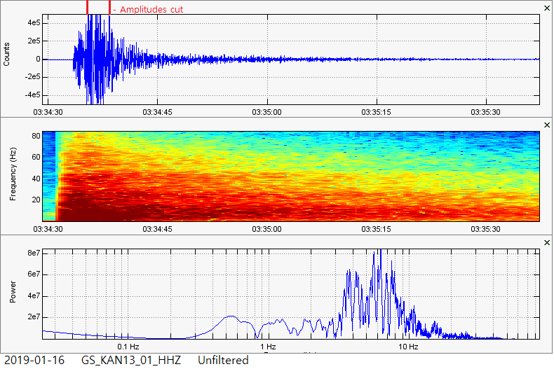 This is the 3-plot image generated using SWARM from the closest seismic station to the M4.0. This earthquake contained some very strong, very high frequencies. Notice the frequency range on the spectrogram is set at a maximum of 85Hz!!! That is officially the highest frequency range I have ever set for a spectrogram. This event was quite strong and many people felt it. The maximum amplitude (strength) on the seismogram/waveform plot is set to 5e5 (500,000), although this station detected amplitudes reaching about 10e5 (1,000,000)! 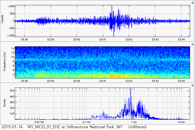 The M4.0 as seen on seismic station MCID (Moose Creek, Idaho) which resides on the southwestern tip of Yellowstone National Park in Northwest Wyoming. Steamboat Geyser's 2nd Eruption of 2019 Around 7:12am MST this morning, Steamboat Geyser within the Norris Geyser Basin at Yellowstone Supervolcano erupted for the 2nd time of 2019 (34th time since it reactivated in early-2018). For a while, the large geyser was keeping an almost near-perfect weekly schedule. However it seems to have skipped an eruption! It has been almost 2 weeks since it last erupted on January 4, 2019. Also, the past 5 or so Steamboat eruptions have been incrementally smaller and smaller. I thought that either Steamboat was dying off or was stabilizing for continued eruptions throughout 2019. This eruption that happened this morning was small in comparison to eruptions in 2018, yes. However it was slightly stronger than the most recent eruption, which occurred on January 4. Do you think Steamboat will die off like it has done throughout the decades? Or will it continue to erupt through 2019? We will have to wait and see. Below is the 3-plot seismic image for the Steamboat eruption that occurred this morning, followed by the helicorder for YNM. It appears to be a typical hydrothermal Steamboat eruption. If you wish to see all of the Steamboat eruptions of 2018, then please CLICK HERE. That will bring you to the Steamboat Geyser 2018 page under the "Seismic Events" dropdown menu. Now if you wish to see all of the current eruptions of 2019, which is usually updated pretty fast whenever a new eruption occurs, then please CLICK HERE. That will bring you to the Steamboat Geyser 2019 page under the "Seismic Events" dropdown menu. I hope you all enjoy and have a great day! I will be back soon! 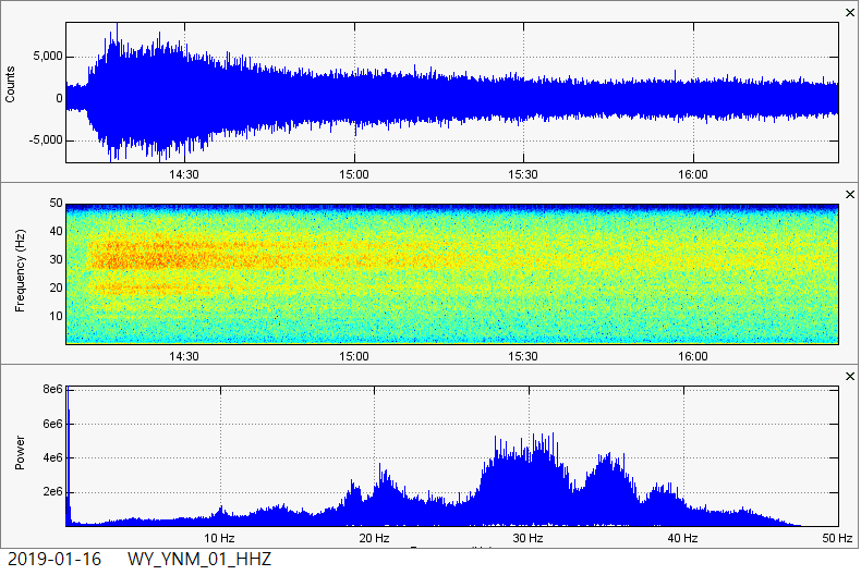 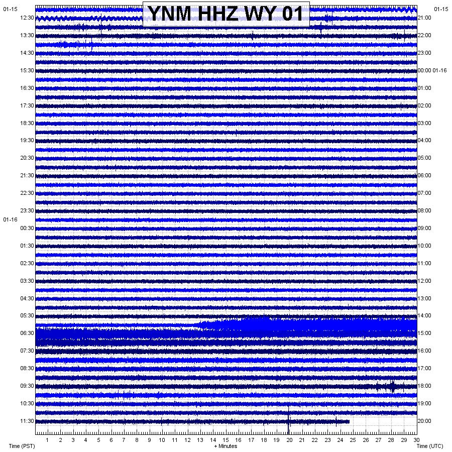
7 Comments
Jennifer
1/16/2019 03:24:54 pm
Excellent information, Ben. Thank you for the update! Continuing to watch it closely and feel much more knowledgeable on it since discovering your website. Thank you for all you do.
Ben
1/17/2019 01:06:04 pm
Awesome! I am glad people are enjoying my work. Thank you much! God bless 1/17/2019 08:31:12 am
The South Haven quake in Kansas was very close to the Nemaha Anticline. This is a prominent uplift running the width of Kansas with origins down around Oklahoma City and terminating up in southern Nebraska along the Mid America Rift. The Nemaha Anticline is the east side of the Mid American Rift. A failed rift valley that was actively spreading for 14 million years about a billion years ago. Drilling has shown the rift is full of at least four levels of sediments covered with lava. Metamorphic rocks under Kansas are some of the oldest in the world. The region is still active as witnessed by our quakes along the Nemaha. I attended a seismic seminar in Washington DC in the year 2000. The gist of the lecture was if the New Madrid in Missouri throws a 7.5, Manhattan, Kansas could get a 6.5 quake in response. Manhattan is very close to the Nemaha Anticline or Ridge The state of Oklahoma has not stopped but curtailed the injection wells and we have seen a notable decrease in quakes lately. This leaves us with quakes that may have natural causes aside from stress caused by injections. Obviously the quake off the coast of Maryland was not caused by injection. Neither was the Steamboat quake in Yellowstone. Stay tuned for further developments along the Nemaha Ridge.
Ben
1/17/2019 01:08:26 pm
Awesome! Thank you for the info. Of course I wasn't saying this M4.0 in Kansas was for sure caused by fracking, but I was just putting out the possibility because of all the research done on it lately (by others, not by myself). Feel free to stop by anytime with more info! God bless
If you get a chance, listen to the sound conversion of the Maryland Atlantic quake. It has a snap to it like tension. Compare it to the compression type events in the 'Ring of Fire'. To me there is a very distinct difference in the sound.
Ben
1/21/2019 01:15:30 pm
Hey mike! Was the sound you listened to of the Maryland quake retrieved using the seismic audio option on the IRIS Time Series URL builder? And in regards to the Kansas quake, I believe that was an error but I could be wrong. Ill check it out again. Thanks for stopping by! God bless Leave a Reply. |
AuthorBen Ferraiuolo is a fast learner and someone who will always stand for the truth. Visit "About Me" for more! Archives
November 2019
Categories |
 RSS Feed