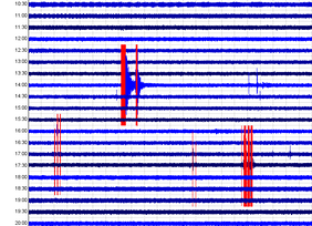
 Hey there again! I am briefly going to show the helicorders and seismogram/spectrogram analysis images for the two earthquakes that recently occurred at Yellowstone on October 21, 2018. These two earthquakes occurred in a very random spot. Usually we see the majority of larger earthquakes (M2.0 and above) occur either near the Maple Creek/Hebgen Lake area, the Norris area, or the northern tip of Yellowstone Lake and West Thumb lake. However today these two earthquakes appear to have occurred at the southern tip of Yellowstone lake, just 2.7 miles south-southwest of seismic station YTP. PLEASE CLICK THE TITLE OF THIS POST TO READ MORE!!! So on October 21, 2018 Yellowstone saw only two noticeable earthquakes. In the images below, and the tiny image above, you can see the magnitude 2.7 earthquake accompanied by another smaller earthquake right after. So far, USGS and University of Utah only decided to report the magnitude 2.7 earthquake. They have yet to report the smaller earthquake that occurred only 1 minute and 10 seconds after the M2.7. The earthquake was reportedly a magnitude 2.7 at 7.3km in depth on October 21, 2018 at 21:07UTC. As you can see directly below, this earthquake occurred 43km ESE of Old Faithful Geyser. This location is at the southern tip of Yellowstone lake and the epicenter occurred only 4.3km (2.7mi) SSW of seismic station YTP (The Promontory). Since station YTP was the station closest to this event, I will use it for any seismogram/spectrogram analysis images I show below. Also below are two seismic helicorders: one for YTP and one for YLT (West Thumb). Please don't forget to pay attention to the captions beneath any images! 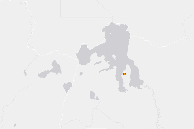 Location of the reported 2.7 earthquake in relation to Yellowstone Lake. It is in a very strange spot! Notice the peninsula the earthquake "dot" rests on? Seismic station YTP is just on the tip of this same peninsula. 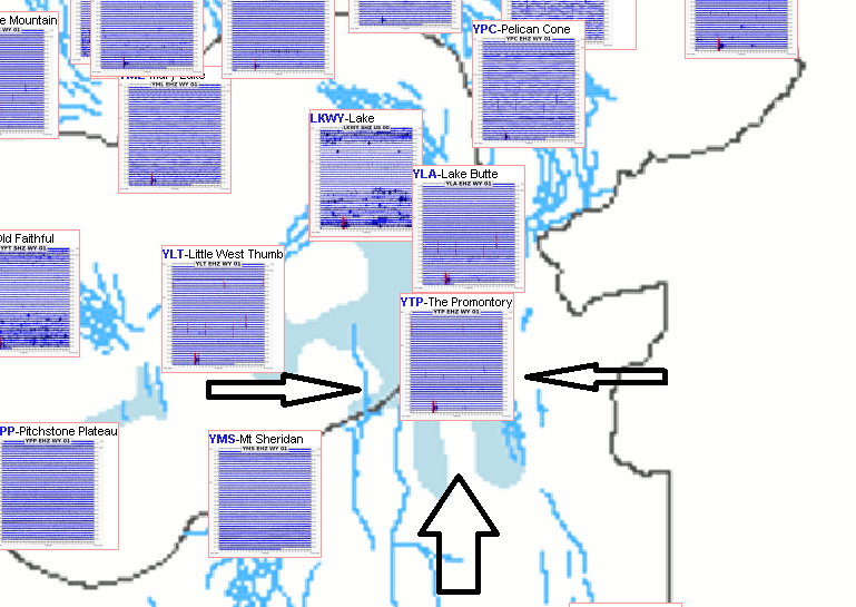 See? YTP is on the tip of the peninsula. Seismic station locations can also be found by going to the IRIS MDA list, clicking "network map" of a random network, entering the network you want, in this case WY, and clicking "update map". If you need the link, please let me know! 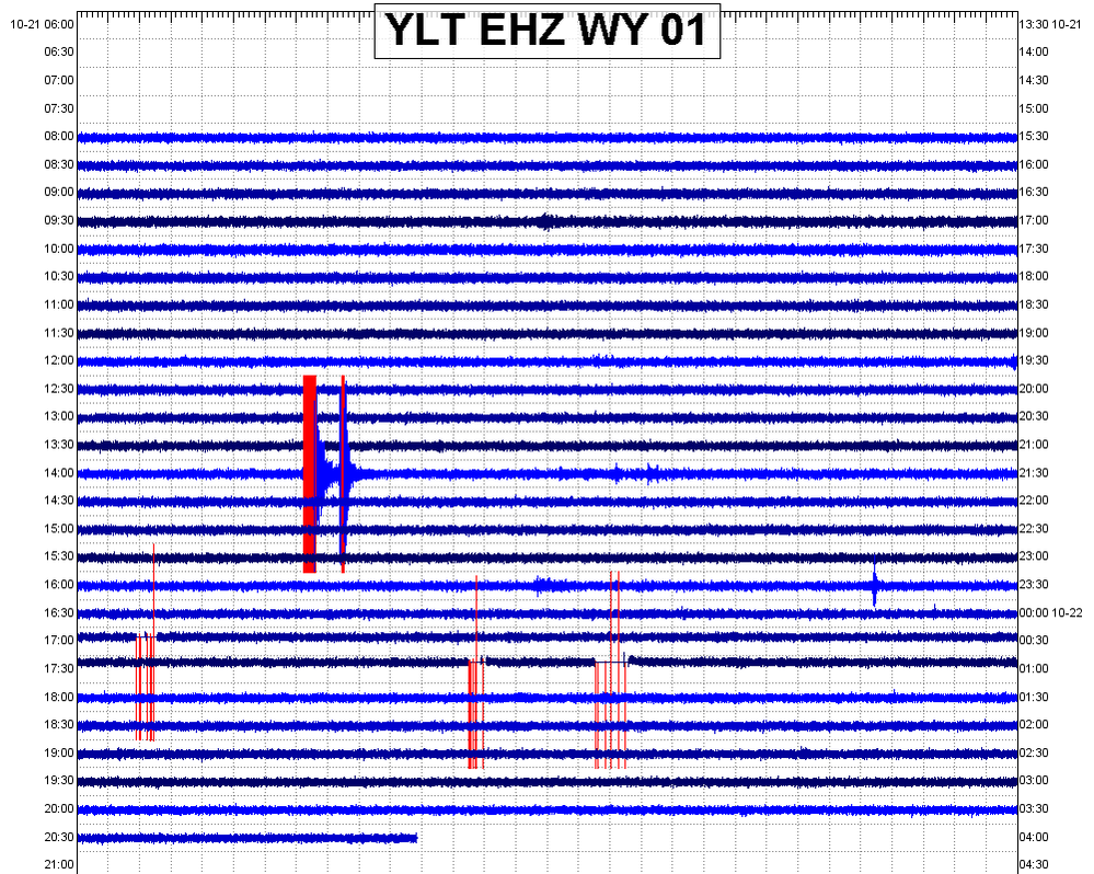 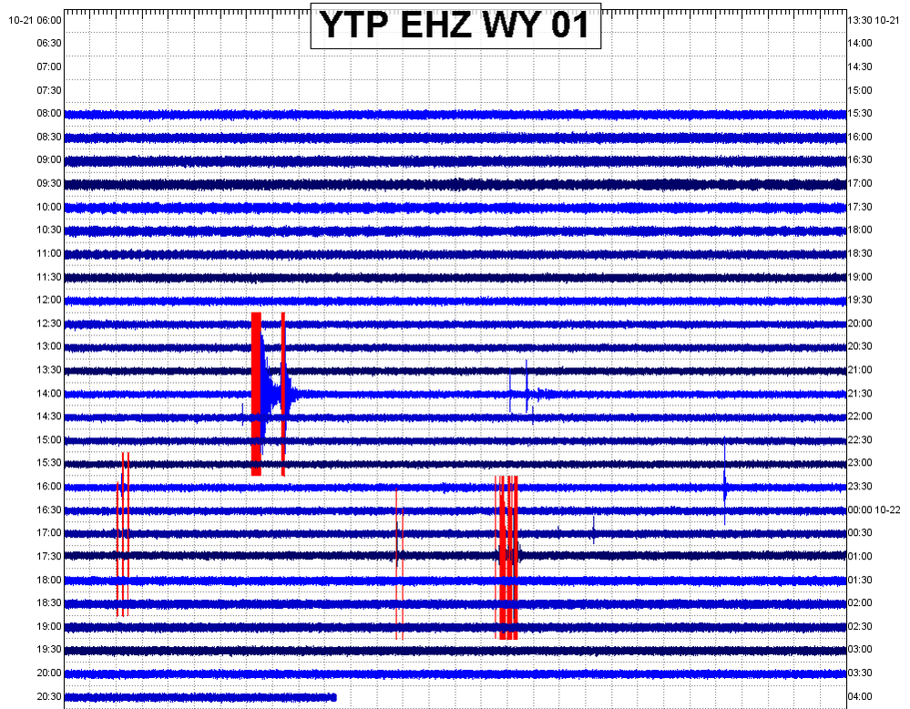 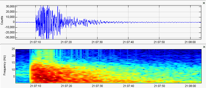 Here is the earthquake they reported. It was reportedly a magnitude 2.7 earthquake which struck at 7.3km in depth. Note the earthquake does contain high frequencies but the dominant frequencies max out at about 15HZ even though the seismic station that recorded this, YTP, was only 2.7 miles NNE of the epicenter. 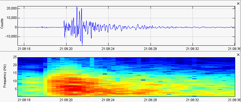 Here is the earthquake USGS and the U of U have yet to report. It occurred literally only 1 minute and 10 seconds after the M2.7 occurred. I am unsure of the depth, since I still am unable to determine depth by myself, but since it maxed out at about 21,000 amplitude count I would say this was about a magnitude 1.8 earthquake. Since the arrivals on surrounding stations appear similar to that of the M2.7 I think it is safe to say this occurred very close to where the original M2.7 struck. Also note the frequency range seems to be almost identical to the M2.7. 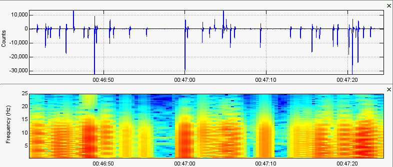 Now some people might wonder why I did not talk about the "earthquakes" that occurred at about 00:46UTC 10/22/18. You can clearly see them on the helicorders! Well that is because they are not earthquakes at all. These seismic stations in this area, including YLT, have been seeing some short, sporadic electronic malfunctions. Just looking at the helicorders you could say that I am lying, since they really do look like earthquakes. But by zooming in, shown in this image directly above, you can tell these events are clearly electronic in nature. Maybe a little static electricity affected the seismographs? Who knows. Thank you again for your time and I hope you have a great day! God bless!
0 Comments
Leave a Reply. |
AuthorBen Ferraiuolo is a fast learner and someone who will always stand for the truth. Visit "About Me" for more! Archives
November 2019
Categories |
 RSS Feed