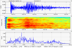
 Hey guys. In this post today I will briefly show some info and data regarding 3 earthquakes that occurred in the past day or so of me writing this. The M4.6, shown first, struck about 80km or so off of Hawaii's southern tip. Could this deep-ish earthquake be related to the magnificient and mysterious Hawaii events that occurred on January 23, 2019? They were after all some of the most impressive and strange seismic events I have ever seen. As usual, please click the title of this post or "read more" if you haven't done so already. 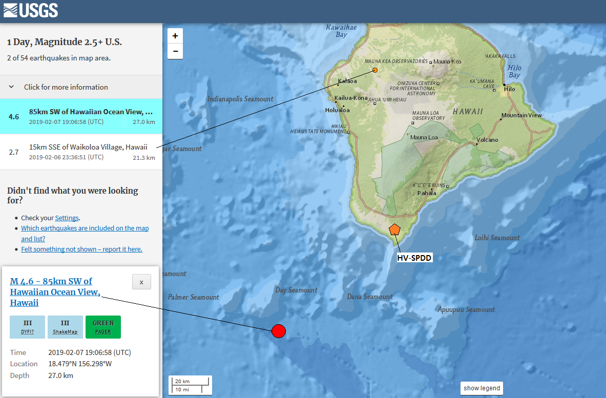 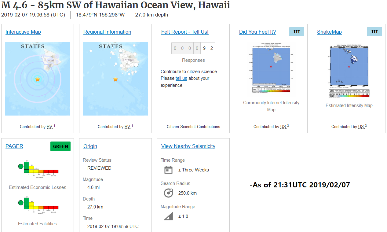 Although it says here 27.0km in depth, the depth was further constrained to 26.8km in depth. The first image you see above shows the location of the M4.6 off the southern tip of Hawaii (marked in red). This event struck at 27km in depth (now revised to 26.8km) on February 7, 2019 at 19:06UTC. This image also shows the location of the closest seismic station to this event: SPDD in the HV network. Notice how it is far off the coast? Could this earthquake be related to the strange seismic events I discovered? If you don't know what I am talking about, please check out my recent blog post by CLICKING HERE. Trust me, those events on January 23, 2019 were absolutely CRAZY. Now the second image you see is the event page of the M4.6 as of 21:31UTC February 7, 2019. Again, the depth was changed from 27km to 26.8km. Over 92 people reported feeling this event which means it is likely many more people felt it. I believe this is the largest earthquake to hit in and around Hawaii since the eruptive activity calmed down in late-2018. Please correct me if I am wrong. Now below I will show the helicorder chart and two 3-plot images for this event. Please remember to always read chart labels first and pay attention to any captions beneath any images. As of February 8, 2019 at 4:44UTC (February 7, 2019 at 8:44pm PST) seismic activity seems to be rising for the Big Island of Hawaii. What does this mean? Feel free to let me know below. 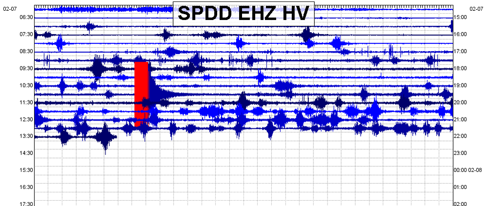 A snippet of the helicorder for station SPDD showing the obvious M4.6. This station, which was the closest one to this earthquake, resides about 80km away and still detected this event quite well! 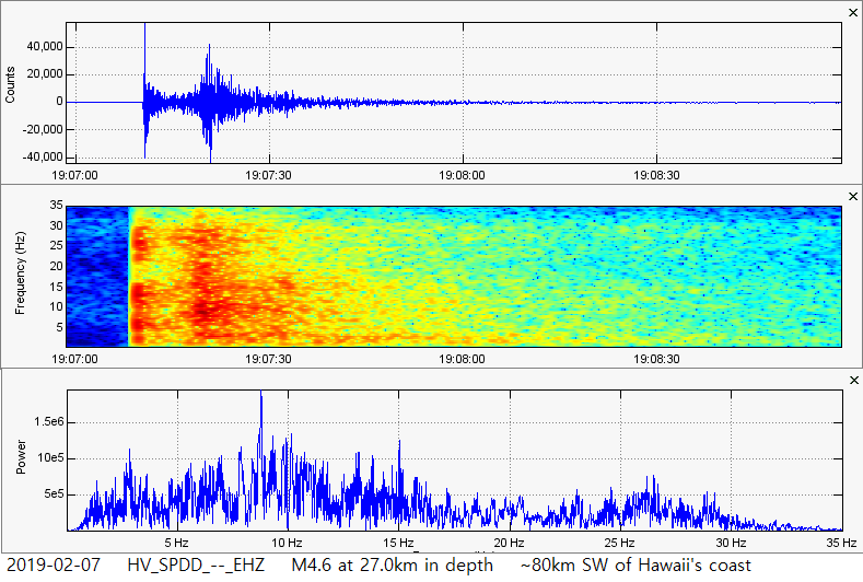 Entire earthquake from start to finish. Note strong frequencies of basically all ranges, though it seemed to be more powerful below the 16Hz line. 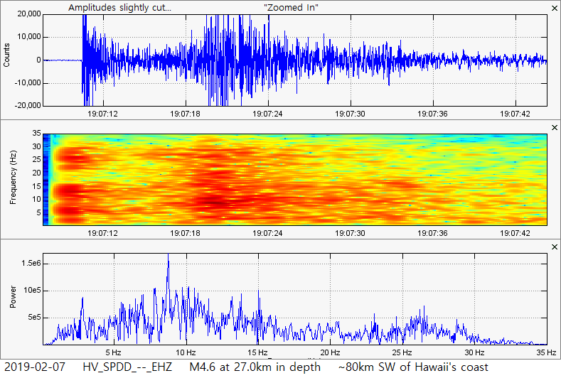 This is the same earthquake from the same station. However I have "zoomed in" and have slightly cut the amplitudes to draw out the smaller activity. Again, although the plots say 27.0km in depth, this event was a M4.6 earthquake at 26.8km in depth. M2.2 Canada - M1.7 Massachusetts 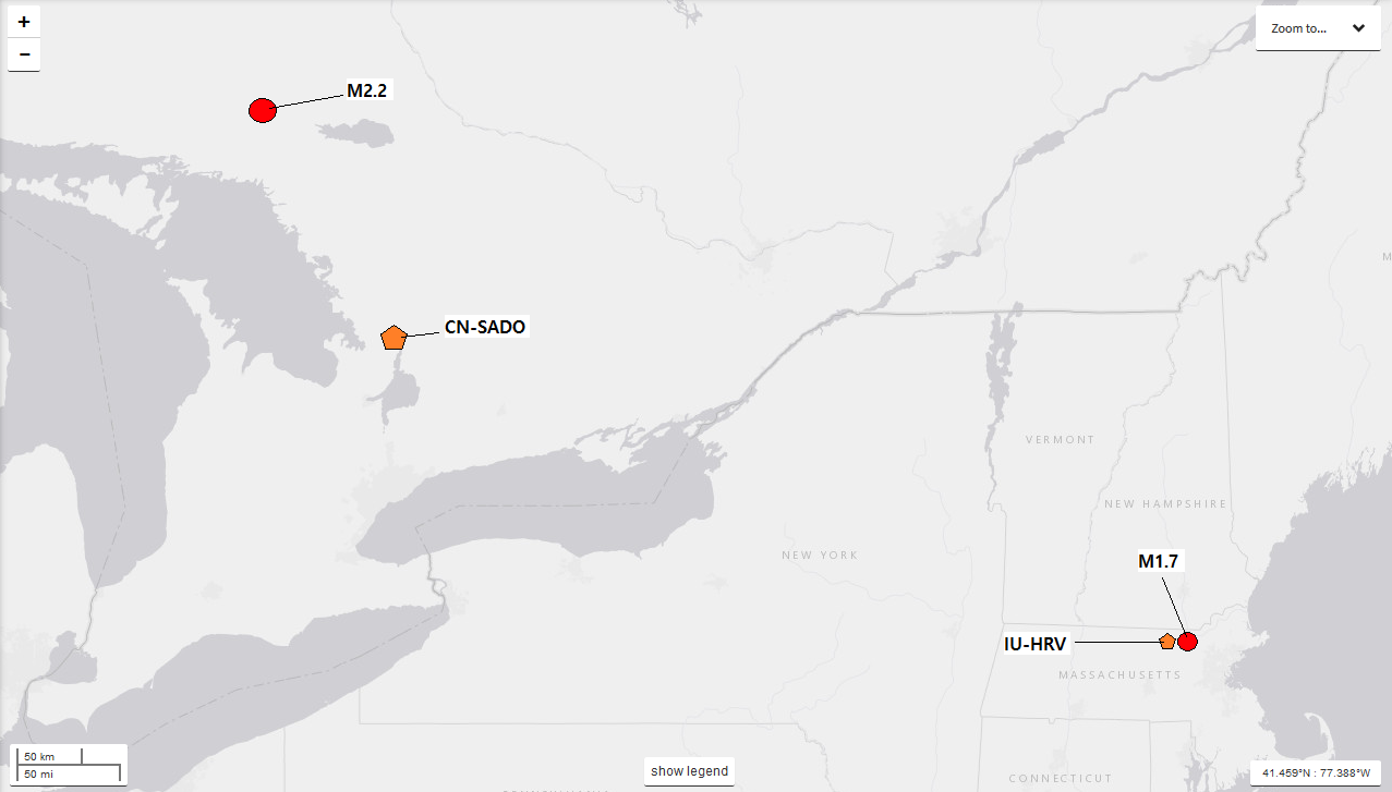 This M2.2 in Canada and M1.7 in Massachusetts is labeled in the image above (marked in red). The orange pentagons represent the closest seismic stations to each earthquake. Below I will show the event pages to each event along with the seismic plots. Remember to always pay attention to chart labels and any captions beneath any images. 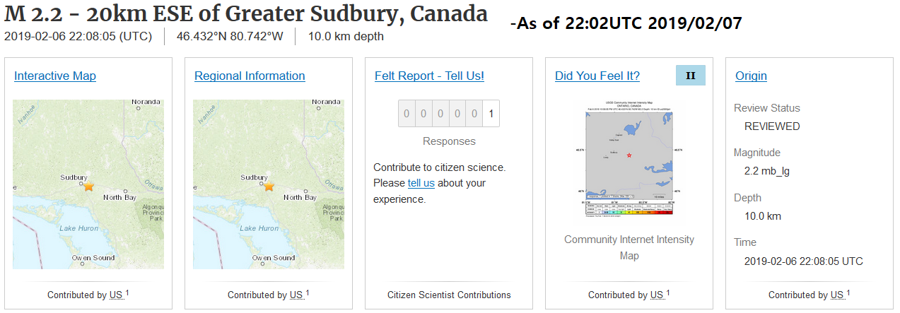 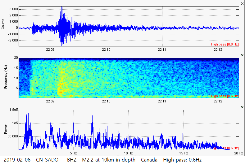 The entire M2.2 in Canada, as recorded by the closest seismic station. This event was reportedly felt by 1 person. If the felt report was accurate, then it is likely a few more people than this felt it. 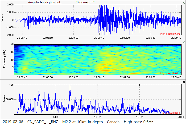 This is a "zoomed in" look at the M2.2 in Canada. Amplitudes were slightly cut to draw out the smaller amplitudes. As the previous plot shows, the dominant frequencies remain below 10Hz and the plots had a 0.6Hz high pass filter added. 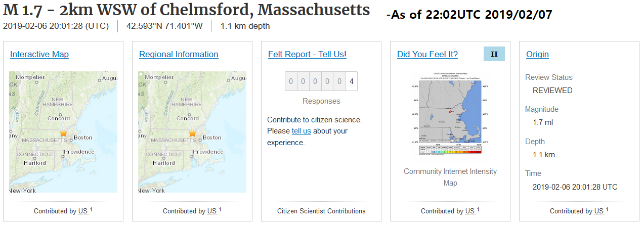 It looks like 4 people actually reported to the USGS that they felt it! That is surprising for a M1.7. It was quite shallow, but still! Although it does happen from time to time, it is rare for multiple people to feel a M1.7. Also, as you can see in the plots below, this earthquake was extremely weird. I cannot even make an accurate guess as to what process caused this event. 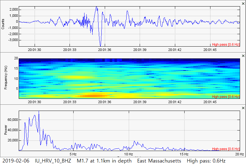 Take a look at the M1.7 at 1.1km in depth in Massachusetts, reportedly felt by 4 people!!! This earthquake is extremely strange. Not only is it strange this many people felt this event, the characteristics of the event are odd as well. Look at the dominant low frequencies! Can this be considered a low frequency earthquake? I am on the fence about that. So what caused this? Why was this earthquake so dang weird? Let me know what you think below!
0 Comments
Leave a Reply. |
AuthorBen Ferraiuolo is a fast learner and someone who will always stand for the truth. Visit "About Me" for more! Archives
November 2019
Categories |
 RSS Feed