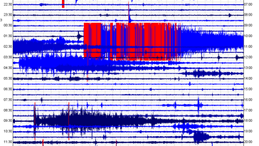
 In this blog post, I will show some info and seismic data to some very peculiar seismic events. One occurred in Alaska, with a possible unreported event just prior, and the rest of the strange events I will talk about occurred in Hawaii. The main focus of the post, however, is the events that occurred in Hawaii. I really do not have a logical interpretation for these events so it would be wonderful if someone could help me understand what these are! Obviously USGS doesn't really understand their origins either, otherwise they would not have been labeled as "Other Event". If you have not already, please click the title of this post or "read more" to continue. CLICK HERE to visit the USGS EQ map for all of the events in this post (and a few more). M1.7 "Other Event" in Alaska 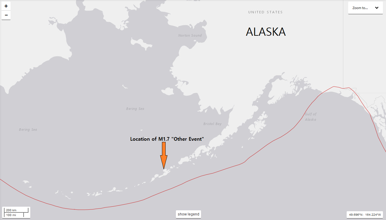 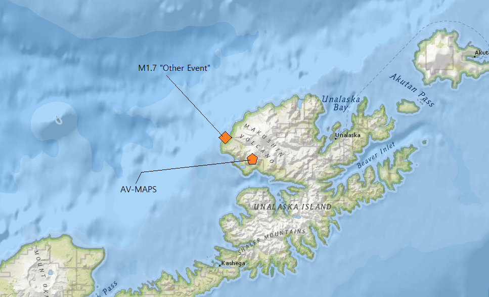 At 20:23UTC on February 3, 2019, a very strange seismic event was reported by USGS for the Makushin Volcano in the Aleutian Island Chain of Alaska. CLICK HERE for info on the volcano itself. Now this M1.7 seismic event, reportedly at 35km in depth, was labeled as "Other Event" by USGS. This is understandable due to the fact that this seismic event was extremely strange. However this comes nowhere close to the extremely peculiar Hawaii events shown below. Now the first image you see above is the location of the M1.7. The second image above shows that as well, however zoomed in to the location showing the closest seismic station to this event: MAPS in the AV network. Below I will show the seismic plots to the M1.7 strange seismic event and a possible unreported event that occurred just about 2 minutes prior to the M1.7. Please pay attention to chart labels and any captions beneath any images. 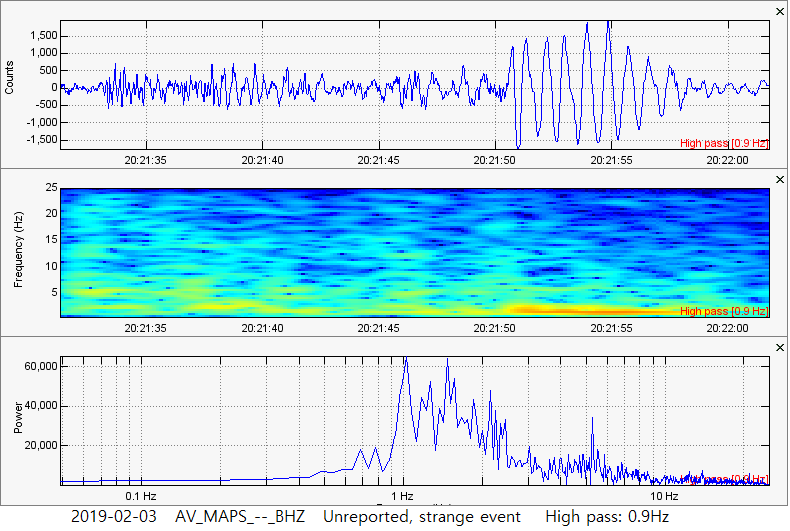 This possible unreported event occurred only about 2 minutes prior to the reported M1.7 "Other Event". This one was very strange and almost looks like some type of volcanic tremor. That interpretation may be incorrect, howevever the characteristics do look somewhat similar. This event contained dominant low frequencies and did not go beyond 2,000 amplitude count, as recorded by seismic station MAPS in the AV network. 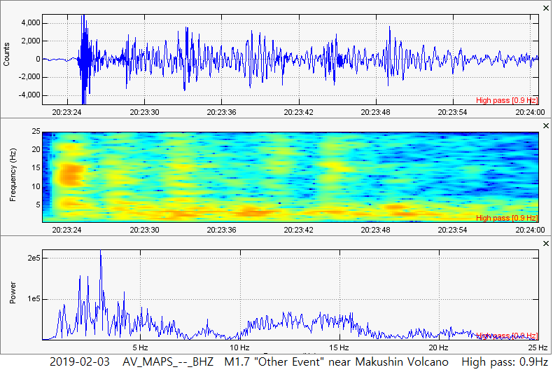 Here is the peculiar M1.7 seismic event labeled by USGS as "Other Event". A high pass 0.8Hz filter was added. This event is strange, yes, but this could be showing 5 earthquakes striking in rapid succession along with low frequency tremor. Very, Very Strange Events in Hawaii 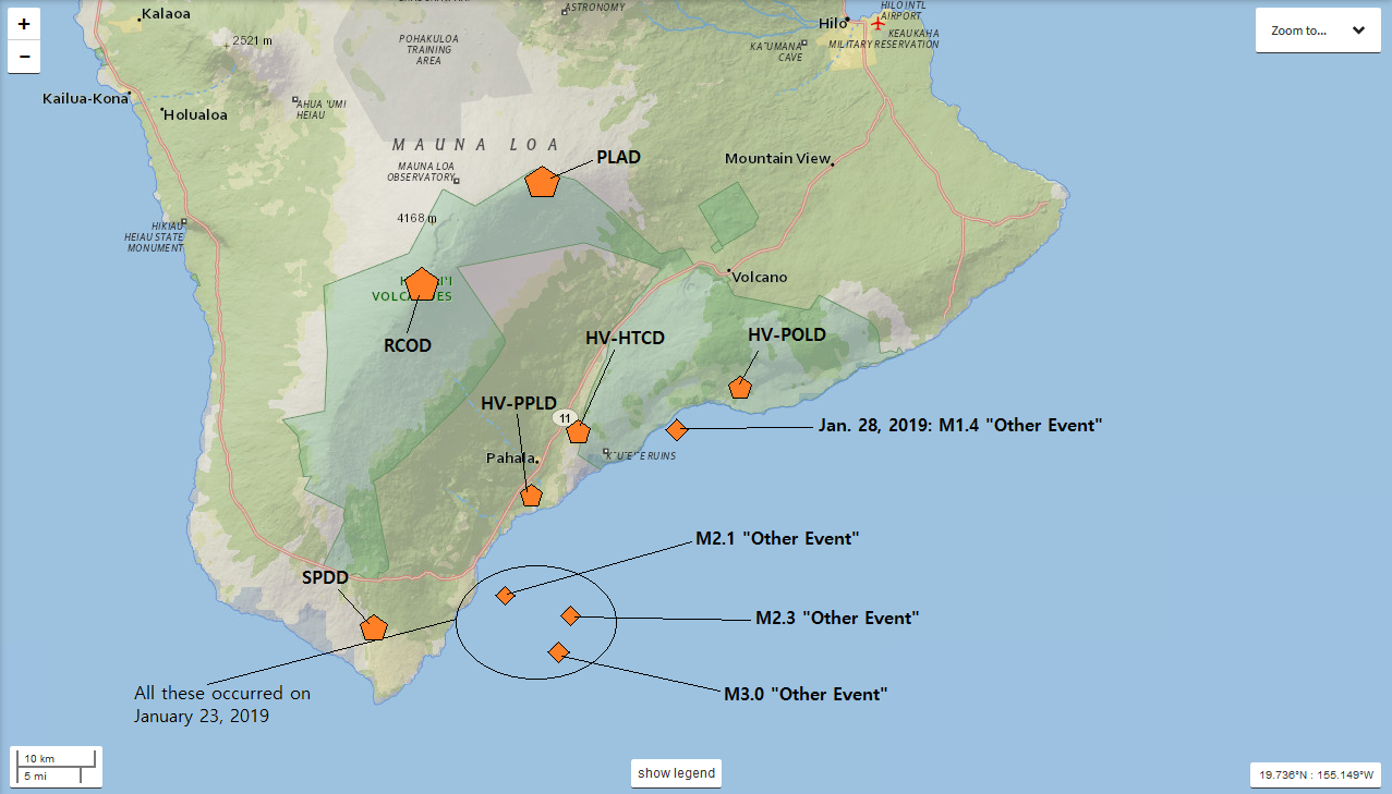 On January 23, 2019, 3 very peculiar seismic events were detected by seismic stations across the Big Island of Hawaii. Then, on January 28, 2019, another peculiar event occurred. Now it is likely the January 28th event, talked about later in this post, is separate from the three January 23rd events (but you never know). All of these events were labeled as "Other Event" by USGS due to their very strange characteristics. First I am going to talk about the 3 "deep long period, high frequency" seismic events on January 23, 2019 near the southern tip of the Big Island of Hawaii. The January 23rd events are ones that I have never seen before. They were deep, but not too deep, striking between 32.9km to 48.1km. One of the more peculiar aspects of these events is that, with time, they would reportedly get smaller and get deeper. Almost giving the illusion something was traveling into the depths of the Earth. In the image above, you can see a few seismic stations marked around Hawaii. The 3 orange diamonds all occurred on the same date, within about 7 hours and 23 minutes of each other. Also, nobody likely felt these events due to how long they lasted, the lack of strong amplitudes (strength), and the depth of the events. However due to the depth, the following seismic traces were recorded all over the Big Island of Hawaii. Now the 4th diamond, the M1.4 "Other Event", will be talked about in a minute. Use the map above if you wish to reference the locations of the seismic stations shown in the data below. You will notice that these events contain high range frequencies but also contain a drastic amount of time compared to their amplitudes, also occurring at a depth much deeper than alot of the seismicity in the area. Because of those characteristics, I am naming this a deep long period, high frequency event. However if this is a new type of seismic event just recently discovered, it would need a much better name than that. Everything about these events has me scratching my head and they are quite amazing. Before I show the data, if you wish to visit the separate events pages to these "Other Events", please click one of the links directly below: -January 23, 2019 10:09UTC: M3.0 at 32.9km -January 23, 2019 12:00UTC: M2.3 at 39.7km -January 23, 2019 17:32UTC: M2.1 at 48.1km First I will show the seismic helicorder chart to one of the stations that detected this event. Note how the events, at first glance, almost look like some weird form of surface noise (i.e. a truck, large herd of bison, etc...). However these events were confirmed to be real seismic events by USGS and fully supported by the data. Then I will show some other helicorder charts in slideshow format, just to give an overview of how some of the stations detected this event. Then, last but not least, I will show the seismic plots I created for these events (I used SWARM, WAVES and the IRIS database). Please always pay attention to plot/chart labels and any captions beneath any images. These events on January 23, 2019 were extremely peculiar!!! Could they have something to do with some type of off-shore volcanic activity? Take a look and let me know what you think! 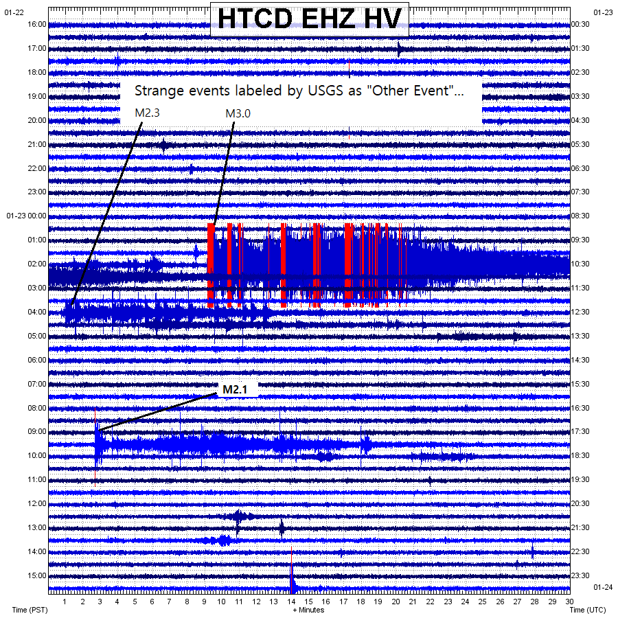 A quick glance at these weird seismic events. They really do look like some type of intense surface noise, however the data (and even USGS) proved these to be very real. Note the extremely long coda with the main M3.0 event lasting almost 30 minutes! What could create such a signature??? 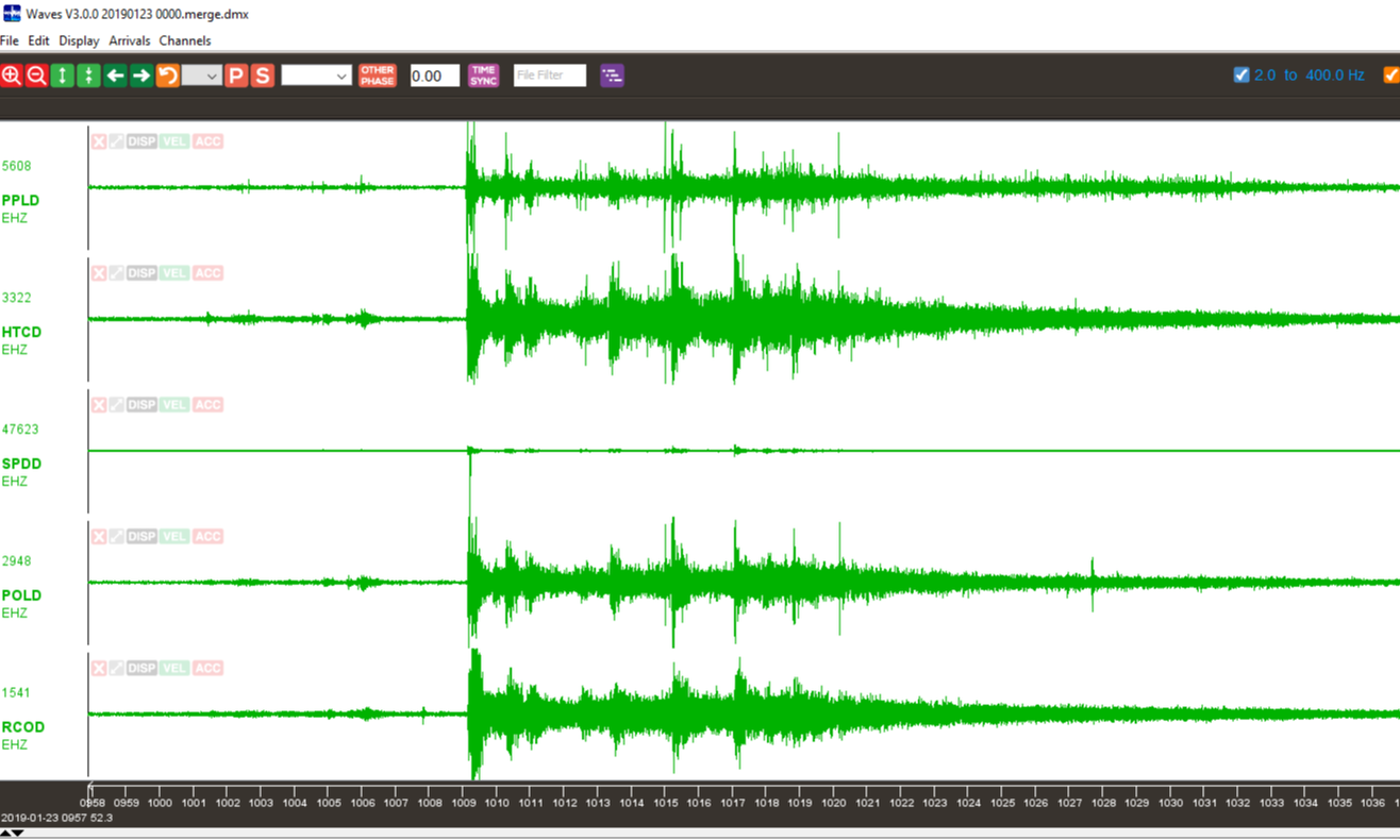 A quick look at the main M3.0 "deep long period, high frequency" event via WAVES. 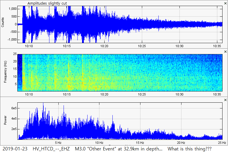 A seismogram/waveform, spectrogram, and spectra plot showing the main M3.0 deep long period, high frequency event. Note it lasted almost 30 minutes!!! 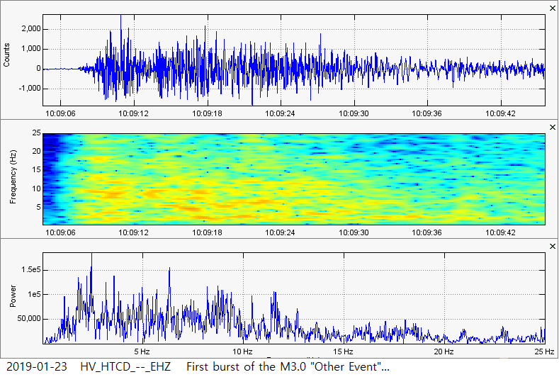 Here we see a 3-plot image visualizing the first burst of energy from the main M3.0 "deep long period, high frequency" event. 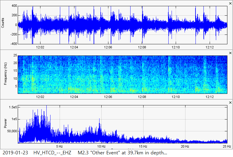 Here is the 2nd reported "Other Event" for January 23, 2019. Notice it is smaller and deeper than the M3.0 that just struck only 2 hours prior. 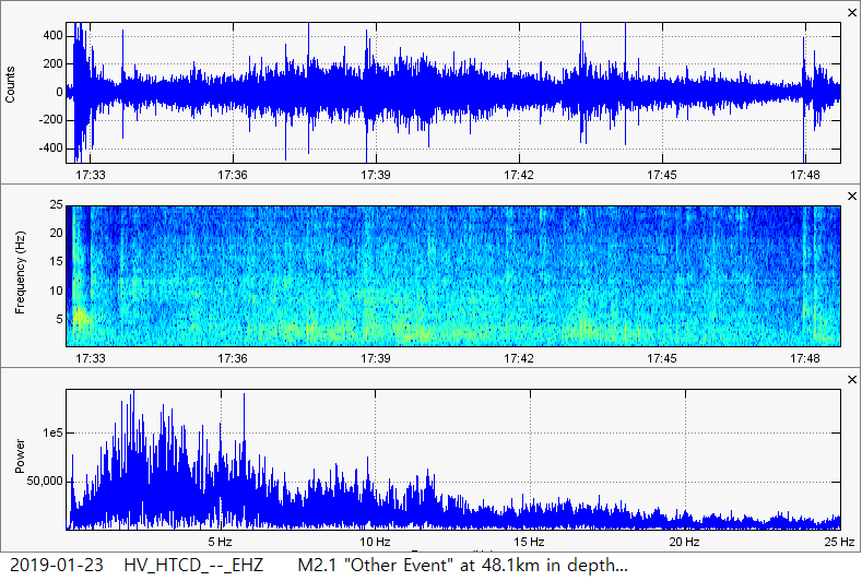 And here is the 3rd reported "Other Event" for January 23, 2019. This one occurred approximately 5 hours and 30 minutes after the most recent reported event. As seen in the event just prior, this event here is also smaller and deeper. So what were these extremely peculiar "deep long period, high frequency" events? Three of them occurred within only 7 hours and 23 minutes but it did look like there were a couple other smaller ones throughout the day. Regardless, what could cause such a signature? Why were the events losing strength while deepening? If you have any idea as to what these could have been, please shoot me an email at [email protected]. Now below I will very quickly show the data to the next event reported by USGS to be a M1.4 "Other Event". This one struck on January 28, 2019, CLICK HERE for the event page, just 5 days after the January 23rd events. Although this one was not as deep, resting around 23.8km in depth, the characteristics look much different than January 23rd events. They could be separate or they could be related. I am unsure. However, check it out! 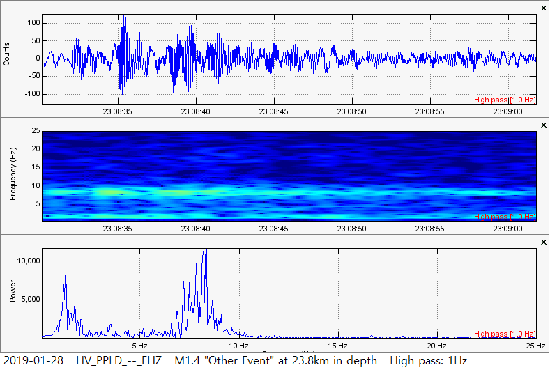 According to USGS, this is the M1.4 "Other Event" that occurred at around 23.8km in depth. This event is extremely peculiar, but again is very dissimilar to the January 23rd events just shown. However I must ask, what is this thing? It is very peculiar and carries dominant low-mid range frequencies. These plots were filtered using a 1Hz high pass filter... 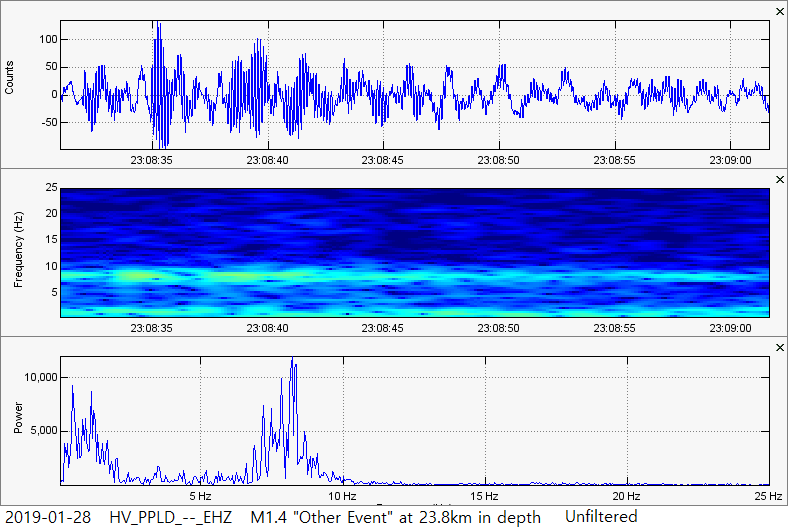 ...and this is the same event but unfiltered. So what was going on in late-January off the coast of the Big Island of Hawaii? Shoot me an email if you can explain these events. Stay tuned! -Ben F.
3 Comments
margaret bosques
6/5/2019 06:28:32 am
though an amateur even my eye riveted on other events in hawaii.i am grateful for your post after many searches to understand.please inform me of additional info.thanks again.mb
Ben
6/10/2019 05:53:05 pm
Awesome! Thank you much for the support. If you goto the "Seismic Events" menu and goto "By Location", click the "Hawaii" page and I have some additional posts there about these events. God bless! Leave a Reply. |
AuthorBen Ferraiuolo is a fast learner and someone who will always stand for the truth. Visit "About Me" for more! Archives
November 2019
Categories |
 RSS Feed