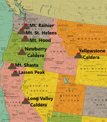
 This is the monthly volcano report for December 2019. If you already know what this usual intro says, please click the title of this post or “read more” to continue. The reported earthquake counts are taken directly from the U.S.G.S. and are only earthquakes reported, not earthquakes recorded. Regarding earthquake counts, it is likely that the reported earthquake total for a given location and time period, mostly during earthquake swarms, is lower than the actual count of earthquakes, in certain cases sometimes drastically lower. Remember, most earthquake swarms at volcanoes do not lead to eruptions. However, almost every eruption is preceded by some type of earthquake swarming and surface deformation. Therefore, swarms and deformation should always be monitored closely regardless of where you think the activity is headed. The volcanoes I will be doing monthly updates on are Yellowstone Caldera in Wyoming, Long Valley Caldera in California, Newberry Caldera and Mt. Hood in Oregon, Mt. Rainier and Mt. St. Helens in Washington state, and Mt. Shasta and Lassen Peak in California. In this update, we will look at reported seismicity counts. If you wish to see recent deformation for Yellowstone or Long Valley, please head to the “Deformation Updates” page which is updated every 2 months or so. The time period of the reported seismicity counts for this update, derived from the USGS earthquake catalog, is from 00:00UTC Dec. 1, 2019 through 23:59UTC December 31, 2019 and magnitudes are always going to be -1.0 and above so you will see every single earthquake that was reported for this time period. The smallest earthquake ever recorded was a M-1.0 and the largest earthquake ever recorded was a M9.5. Also, the coordinate box I use for each volcano is exactly the same every month, so you always see the activity that occurred in the same area every month. Regarding the 3-plot seismic images I generate for the largest events, I will always try my best to use the closest seismic station to any given event. I will also add the link to the USGS EQ map showing the locations of reported seismicity for the location and time period in question.
0 Comments
|
About
I used to create monthly volcano updates as videos for my YouTube channel and my website. However, that took far too much time and I have had to discontinue those updates. That being said, I will now do monthly volcano updates via this blog here. I will try to get them out as soon as possible. However, if I am very busy, they may be as much as 1-2 weeks late. Archives
February 2020
Categories |
 RSS Feed