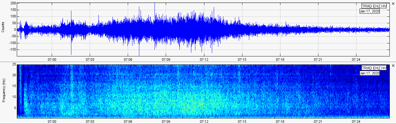
 Jan. 17, 2020 spasmodic tremor as seen on station TRAD in the HV network. Quakes, spasmodic tremor, and continued deformation is the name of the game during these past two months. Spasmodic tremor continued to decline in December 2019 and January 2020. There was even an increase in swarming and M3+ earthquakes late-January. Please click the title of this post or "read more" to continue... Mauna Loa is currently experiencing heightened volcanic unrest, including increased seismicity and uplift (i.e. swelling, inflation). Therefore, the alert level has been raised to ADVISORY and the aviation color code has been raised to YELLOW. Please CLICK HERE to keep up to date with recent alert postings by USGS/HVO for Mauna Loa’s potential eruptive activity in the near future. 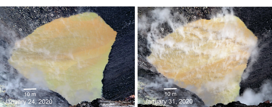 CREDIT: HVO/USGS As seen in the picture above, a pond of water larger than a football stadium has been constantly growing at the bottom of Halema’uma’u crater inside of Kilauea Caldera. It was originally thought to be rainwater, but USGS/HVO now confirms this intrusion is deeply rooted in groundwater. This could possibly spell trouble for Kilauea in the future. Sulfur dioxide is actively dissolved in the lake making accurate SO2 readings for rising magma extremely difficult. To keep an eye on this growing lake, keep checking the Volcano Watch articles put out by HVO which can be found HERE. Also, you can keep an eye on it yourself if you monitor the webcams at Kilauea which can be found HERE. Picture and video updates from HVO can be found HERE (< that's my favorite way to monitor the growing lake). If you click a certain webcam you can see a time lapse of the past 24 hours. Please click the USGS earthquake map button directly above. There were 1,053 reported earthquakes from Dec. 1, 2019 through Jan. 31, 2020 for the entire island chain of Hawaii. In those two months, ~75% of the reported earthquakes occurred deep under Pahala, HI within the mantle plume conduit(s), right where spasmodic tremor occurs. Speaking of spasmodic tremor... Notice those deep earthquakes (25km to 60km depth) under Pahala, Hawaii? Well, those are occurring within the mantle plume where spasmodic tremor has recently been prevalent. If you wish to understand what volcanic spasmodic tremor is, and how it relates to ongoing volcanic unrest in Hawaii, please CLICK HERE. Before I get to showing spasmodic tremor for December 2019 and January 2020, I wanted to quickly notify you about an increase in seismicity which started on January 29 and continues to the time I am writing this, 08:07UTC Feb. 3, 2020, though in diminished form. Spasmodic tremor over the past 7 months has slowly been replaced by earthquake swarms for the same hypocenters as the spasmodic tremor events I have widely talked about and shown data for. Deep swarming within the mantle plume conduit(s) under Pahala, HI are nothing new since the eruptions on the Big Island stopped in Sept. 2018. However, January 29, 2020 saw quite an interesting increase in seismicity coupled with an increase in high M2s and some M3s in the shallow crust around Kilauea and the Lower East Rift Zone. It is interesting to note many earthquakes ranging from M2.9 to M4.2 started striking around the Big Island volcanoes during this time range of increased deep seismicity under Pahala, HI, showing there must be a connection in some way of the deep magmatic processes occurring within the mantle plume conduit(s), which feed the volcanoes on the Big Island, and activity that occurs in the more shallow portions of the crust around Kilauea and the LERZ. Just a few of the larger earthquakes during that time frame are shown below (CLICK HERE to see the USGS EQ map of Hawaii for Jan. 29, 2020 through Feb. 4, 2020; map will be automatically updated if it isn't Feb. 4 yet): -M4.2 at 7.7km depth on Feb. 3, 2020 at 06:37UTC ~9.5km SE of Kilauea and 10km SW of Pu‘u ‘Ō‘ō (over 300 felt reports; largest earthquake on Big Island since the deep M4.9 at Mauna Kea on November 11, 2019 and the largest at Kilauea/LERZ since the M5.5 at 7.0km depth on March 13, 2019 which struck basically in the same location) -M3.8 at 5.5km depth on Jan. 29, 2020 at 22:23UTC ~18km ESE of Pu‘u ‘Ō‘ō along the coast (73 felt reports) -M3.2 at 31.7km depth on Feb. 1, 2020 at 22:33UTC under Pahala, HI within mantle plume conduit -M3.0 at 7.2km depth on Jan. 30, 2020 at 11:51UTC just south of Pu‘u ‘Ō‘ō (4 felt reports) -M3.0 at 32.0km depth on Feb. 1, 2020 at 13:48UTC under Pahala, HI within mantle plume conduit -M3.0 at 3.0km depth on Feb. 1, 2020 at 13:48UTC just a few km south of Pu‘u ‘Ō‘ō and struck at the same time as the quake listed directly above Of course M3.0 earthquakes are nothing to worry about and are not major by any standard. However, M3+ quakes rarely have struck the Big Island for many months now, especially the recent M4.2. When we see an increase in seismicity within the mantle plume conduit(s), coupled with an increase in higher magnitude earthquakes in the shallow crust, we must see there is some correlation. The exact correlation still eludes me to this day. The helicorder plots in slideshow format below show quakes from 13:00UTC Jan. 29, 2020 to 10:05UTC Feb. 2, 2020. 136 quakes were reported during this time frame for the Big Island. Of course, some were not able to be located accurately so this count is likely slightly higher. However, 88 quakes were reported in the deep mantle plume conduit(s) beneath Pahala where spasmodic tremor occurs. That means over 75% of the recent increase in seismicity, and the earthquakes you see on the helicorders below, occurred within the mantle plume conduit(s). Helicorder plots were filtered with a 1.1Hz high pass filter and were retrieved using the IRIS TimeSeries tool. Whenever the location code is --, and the data is downloaded from the TimeSeries tool, a glitch occurs on the helicorder plots where the location code is shown as -12345, as seen below. I am unsure why this glitch occurs. Here are seismogram plots from the six closest stations to the M4.2 that occurred on February 3, 2020: 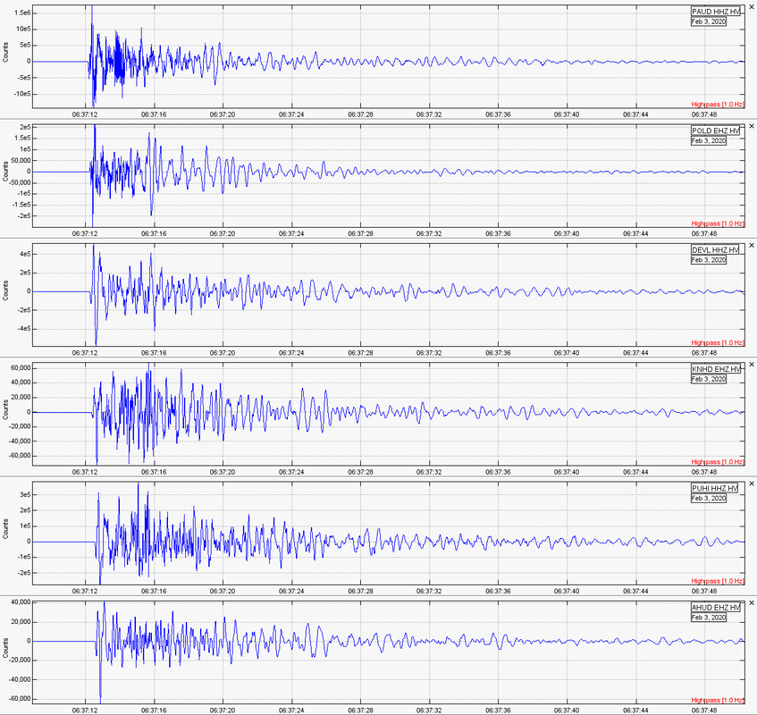 Here are the spectrogram plots from the same stations listed above of the M4.2: 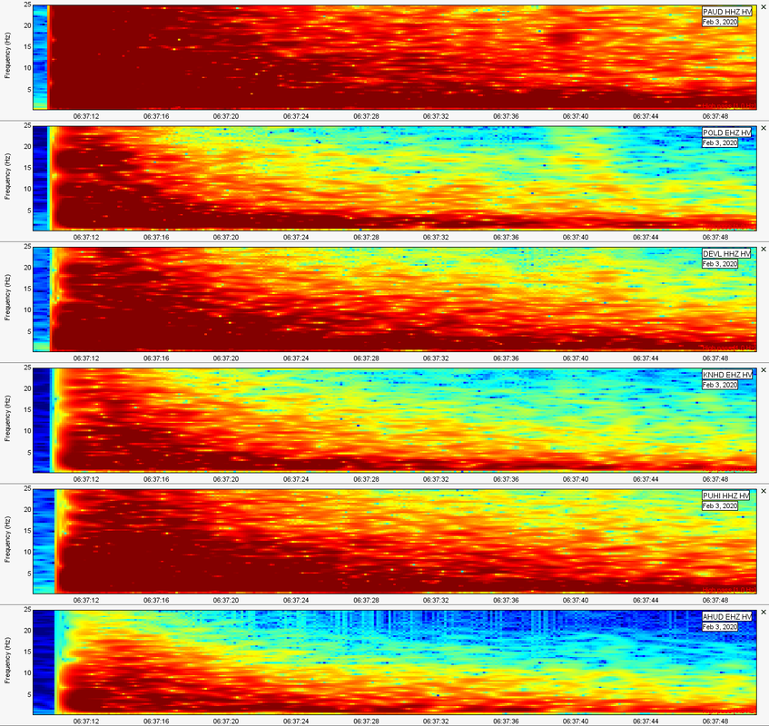 Now, let's get to all spasmodic tremor events which occurred for both December 2019 and January 2020. Remember, seismic audio is included beneath the plots. An 8,000 audio frame rate (samples per second) was used to increase the speed greatly of the audio to allow for easy listening to each spasmodic tremor event. The IRIS TimeSeries tool was used to retrieve this seismic audio from station PPLD and the IRIS DataSelect tool was used to retrieve the seismic data. Event 1 This spasmodic tremor occurred on December 7, 2019 at 14:05UTC. It was weak lasted a mere ten minutes, which is the shortest spasmodic tremor I have encountered. 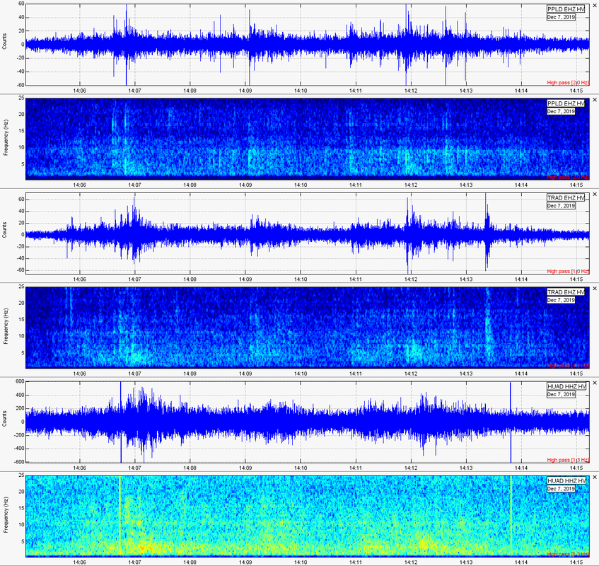 Event 2 This spasmodic tremor occurred on December 18, 2019 at 19:20UTC. Again, it was weak and lasted only ten minutes. 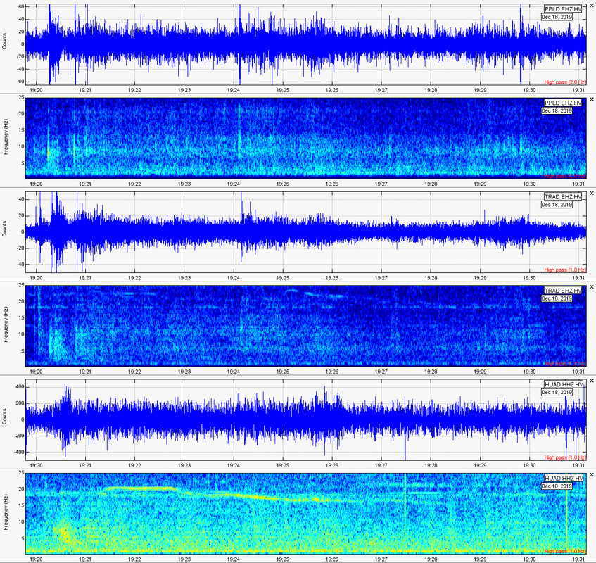 Event 3Spasmodic tremor occurred on December 18, 2019 at 21:22UTC. It was so weak I almost missed it and it lasted only 19 minutes. 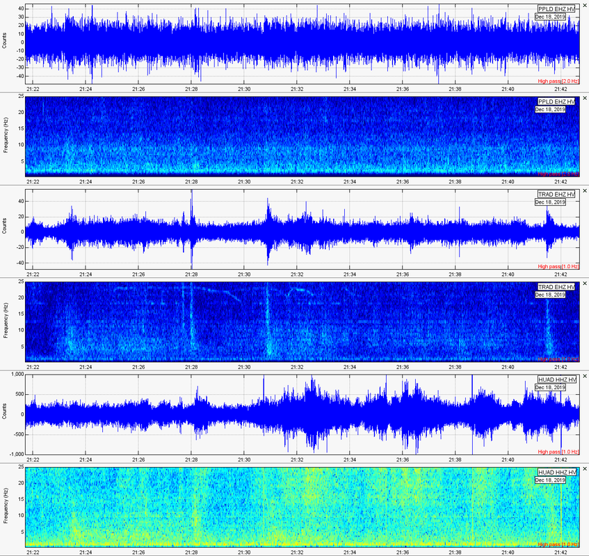 Event 4 Spasmodic tremor occurred on December 29, 2019 at 09:08UTC. It was weak and lasted 36 minutes. The earthquakes that you can see may or may not be related to the spasmodic tremor of this day. 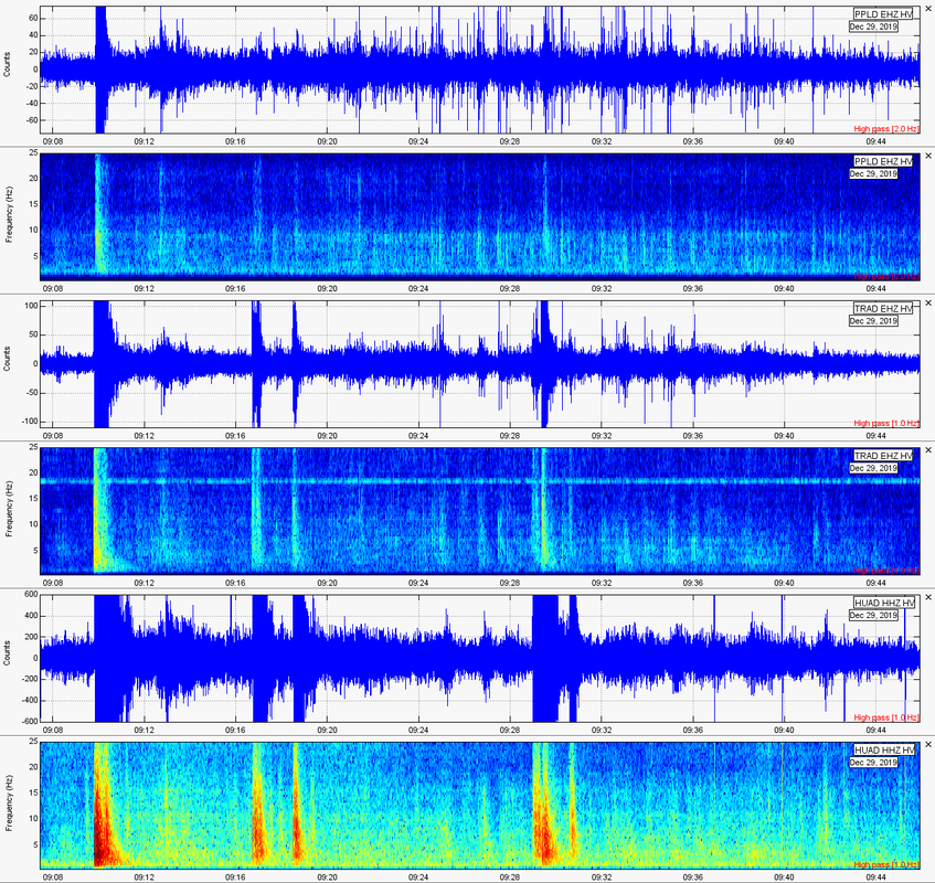 Event 5 Spasmodic tremor occurred on Dec. 29, 2019 at 09:48UTC. It was the strongest of December 2019 and January 2020 and lasted 36 minutes. 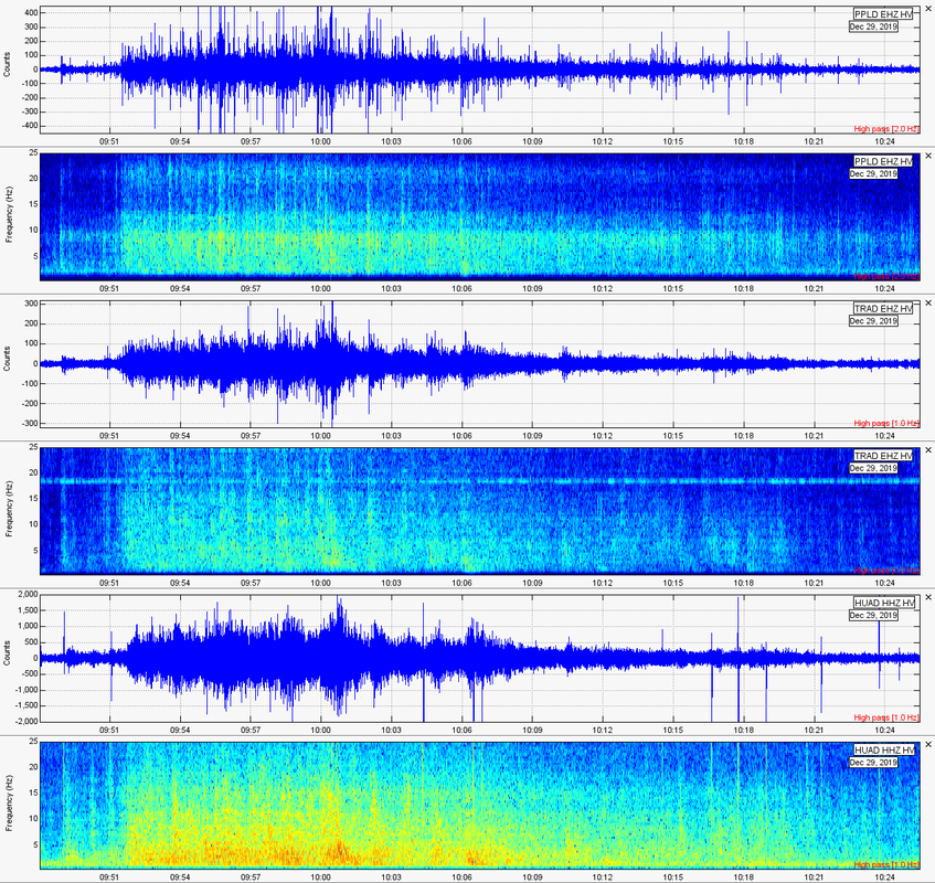 Event 6 Happy New Year!!! Spasmodic tremor occurred on Jan. 16, 2020 at 18:44UTC. It was extremely weak and I almost missed it. This tremor lasted only 19 minutes. 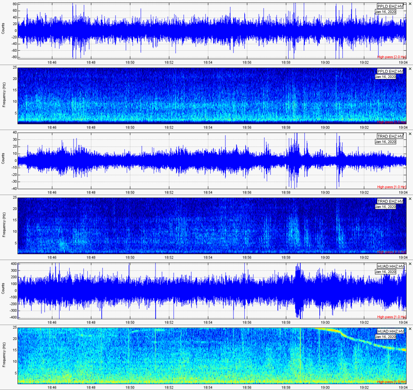 Event 7 Spasmodic tremor occurred on Jan. 17, 2020 at 06:57UTC. It was arguably the 2nd strongest spasmodic tremor of December 2019 - January 2020 and lasted 30 minutes. 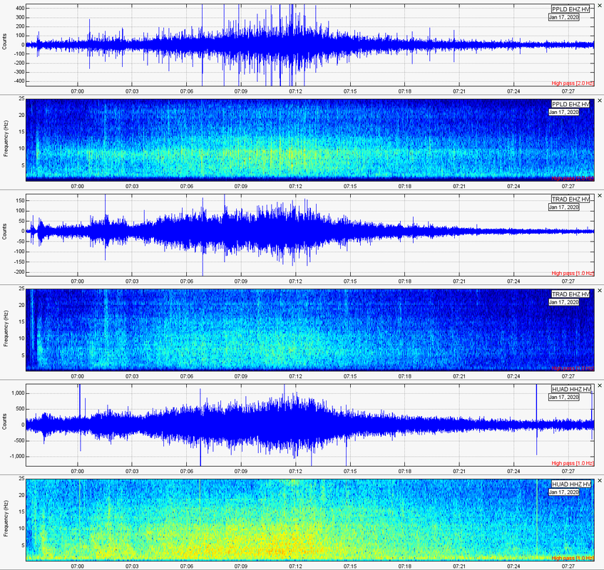 Event 8 Spasmodic tremor occurred on January 29, 2020 at 10:45UTC. It was sort of weak but surprisingly lasted 40 minutes. 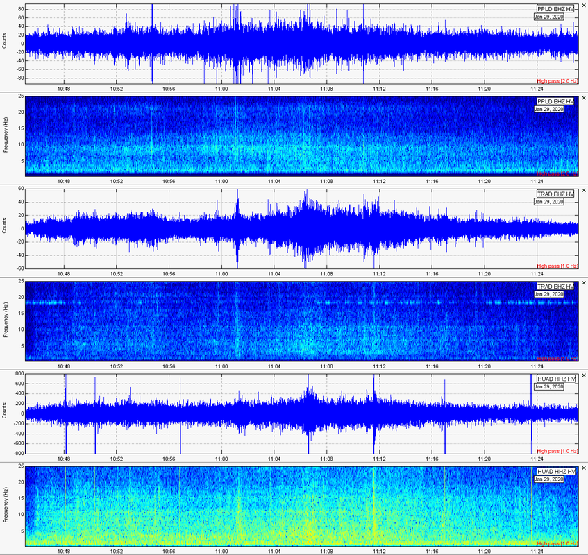
1 Comment
2/6/2020 04:23:12 am
I love your reports I've learned a lot from you. Thank you. God bless you and your family Leave a Reply. |
About
This blog is specifically for activity that occurs in Hawaii. In light of 2018's eruptions on the Big Island, I felt it necessary to have a section entirely devoted to events in Hawaii. I now mostly use this blog to update people on volcanic spasmodic tremor which occurs deep within the mantle plume conduit(s) under Pahala, HI. Don't know what spasmodic tremor is? Don't fret! Simply go to the Hawaii menu and click the page about Hawaii Spasmodic Tremor. Archives
February 2020
Categories |
 RSS Feed