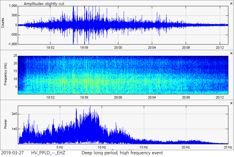
 One of the strange long period earthquakes that occurred on March 27, 2019 just off the coast of Pahala, Hawaii. Between March 27 and March 28, 2019, three extremely odd seismic events were detected on virtually every seismic station across the Big Island of Hawaii. They are emergent, meaning they slowly build, they primarily occur between 30km and 50km in depth, they travel quite far compared to their relatively low amplitudes, they carry mid to high range frequencies and can last anywhere from 15 minutes to 1 hour. If you wish to continue this post and review some of the data I have for you, please click the title of this post or "read more" to continue... Information and data as of 2:20UTC March 28, 2019 (7:20pm Pacific Time, March 27, 2019) Post last updated/posted: 5:32UTC March 28, 2019 (10:32pm Pacific Time, March 27, 2019) 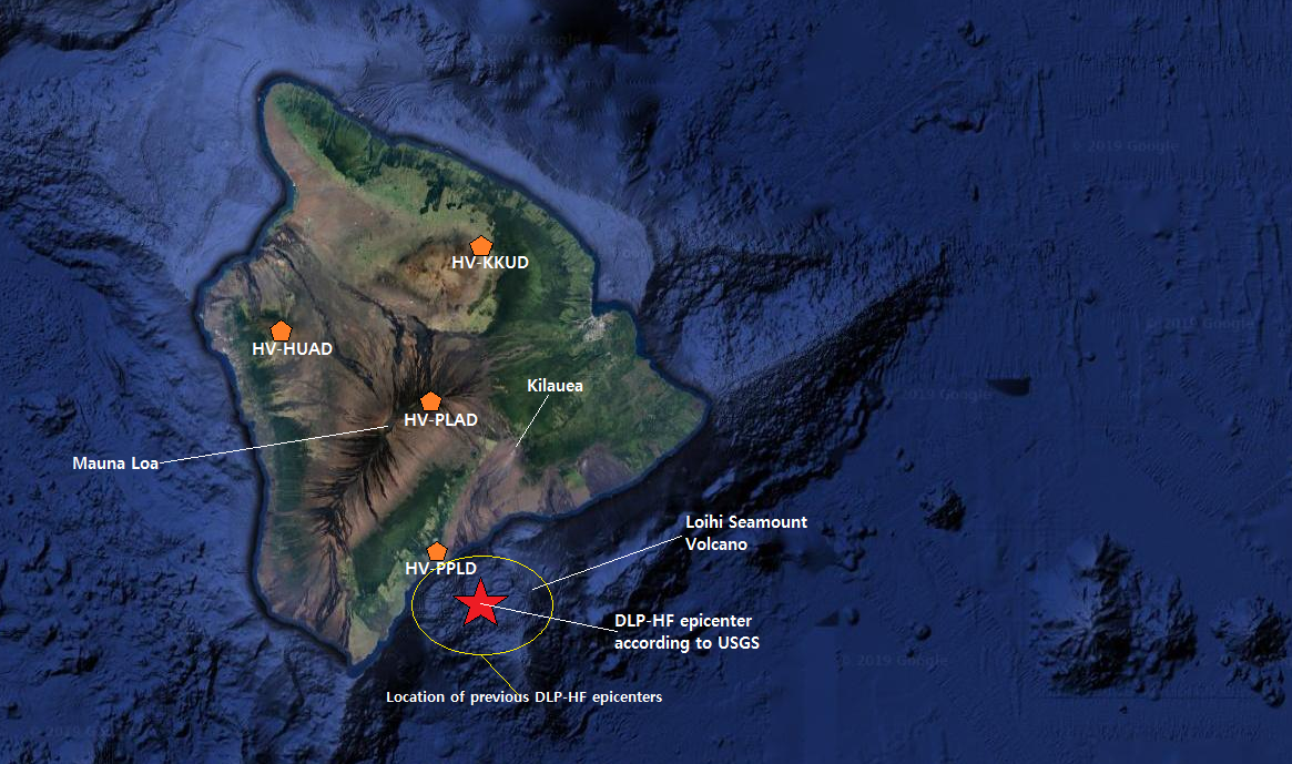 In the picture above you can see many labels. The four pentagons are the four seismic stations I will use for any analysis conducted below. Please note they are many miles from each other, all across the Big Island of Hawaii. Mauna Loa, Kilauea, and Loihi volcanoes are all marked. The red star indicates the epicenters of today's deep long period, high frequency events (DLP-HF for short). Remember, this is not the first time these DLP-HF events have occurred. In fact, I believe one did occur just after the M5.5 in the beginning of this month (not shown here). But prior to that, they were last seen on January 23, 2019 virtually in the same location. The yellow circle in the picture above shows the recent epicenters of previous DLP-HF events. Again they are emergent, meaning they slowly build, they primarily occur between 30km and 50km in depth, they travel quite far compared to their relatively low amplitudes, they carry mid to high range frequencies and can last anywhere from 15 minutes to 1 hour. These quite possibly are the most interesting seismic events I have ever had the chance to study! These seismic events are not just confirmed by me, but also by the Hawaiian Volcano Observatory and the USGS. Before I show the data, there are a few points I would like to address: -Today is not the first day these events have been detected. For example, January 23 of this year, 2019, there were a few of them as well! Some of them being even stronger than the events detected today. If you wish to see some of the data in the blog post I created about those events, please CLICK HERE. Scroll past the Alaska event which is shown first, if you wish. -These events are very real and have been detected on seismic stations all across the Big Island of Hawaii. USGS and the HVO has labeled them as "Other Event", seeing there is not other way to officially describe them. I have named them "deep long period, high frequency events", or DLP-HF events for short. -If you wish to see the USGS earthquake map for this time period and this location, which includes these events and event pages, please CLICK HERE. I am not attaching the magnitudes to these events, which were actually reported by USGS and HVO. This is because, in my opinion, magnitudes don't really work. These events last very long and are an emergent, tremor-like event. Regardless of this, if you wish to connect the events shown below to the events reported, especially their reported depths which are accurate, please click the link in this paragraph. When on the map, click refresh just in case. -Although I only show the data from 4 select stations across the whole Big Island of Hawaii, it is likely almost every single station on the island detected these events. Now how did it travel so far and so quickly while the amplitudes were low? It is likely because these events were deeper than usual seismicity, likely striking between 40km and 50km in depth. -Below you will notice webicorder/helicorder charts, 3-plot images, and seismograms shown in the program WAVES: -When looking at the webicorders/helicorders in slideshow format, quickly press the arrows in the top right corner of the slideshow to see how the events correlate between distant stations. -The four green seismograms shown via the program WAVES are from the four stations labeled on the map in the beginning of this post. Note the great distance between stations and how they compare on the green seismograms. -The 3-plot images are generated using the seismic program SWARM. All of these different programs, accessibility options, and techniques can be acquired by perusing multiple pages here on my website. Since there were 3 events detected between March 27 and March 28 of 2019, I will show the data to each separate event. Afterwards I will show any additional info or data. Remember these events have already been confirmed by the HVO and USGS to be real seismic events. 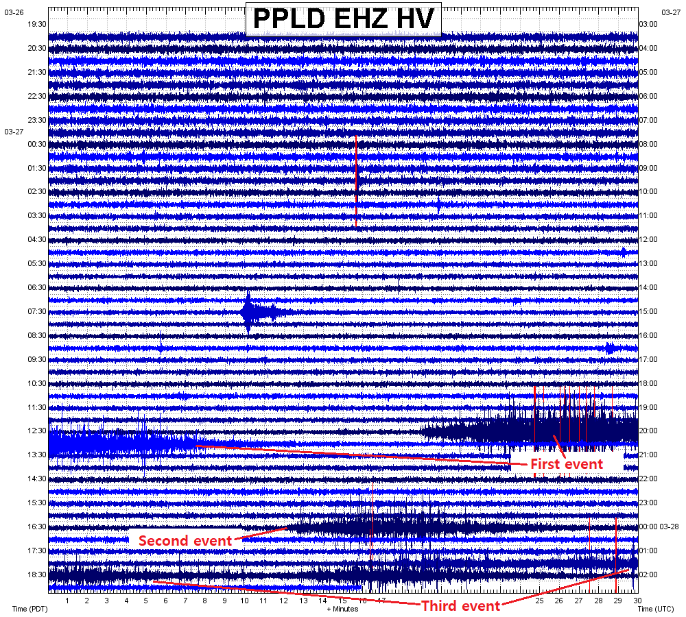 A custom helicorder generated by myself using the seismic program SWARM and data taken from the closest seismic station to the epicenter of these events. Notice how strange they look? These events showed on virtually every single seismic station on the Big Island of Hawaii. And real quick, here are the 4 custom helicorders for the 4 select seismic stations labeled on the map in the beginning of this post. If you wish to see many more helicorders, in this case "webicorders", from stations all across the Big Island then please look at the end of this post. First event: 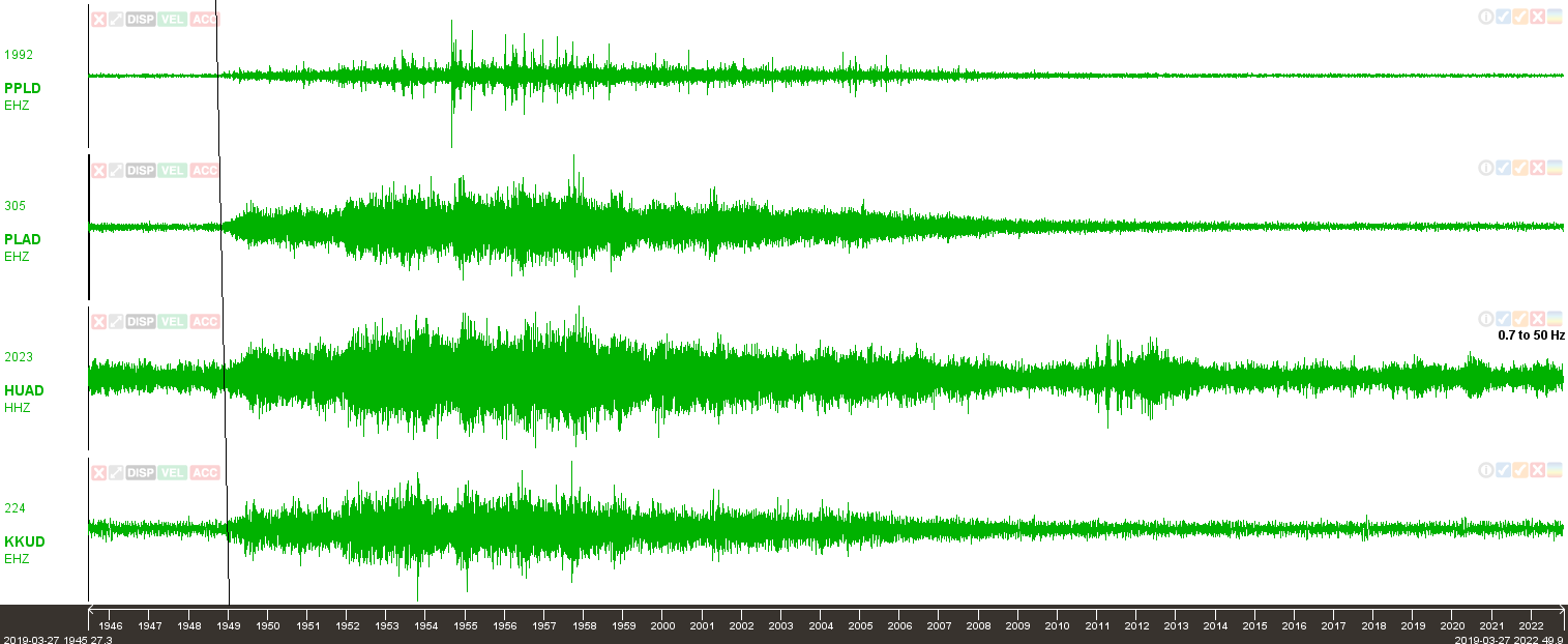 This is the first event which started at about 19:48UTC on March 27, 2019 and lasted about 25 minutes. The image above is of four seismograms from the four seismic stations labeled on the map in the beginning of this post. Although the seismic stations a a great distance from each other, and this event was not too strong in amplitude, it still traveled very quickly to distant stations. The four stations labeled in the seismograms above are also shown in the slideshow below: 2nd event: 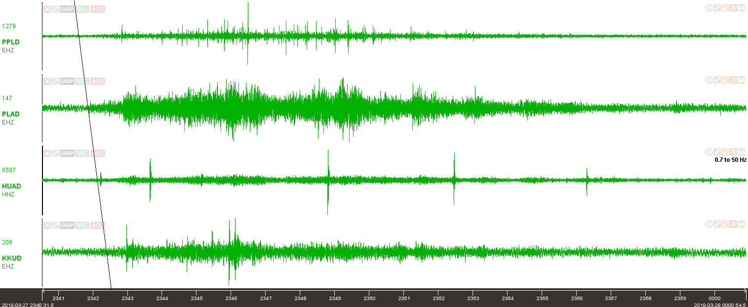 Here is the 2nd event which started at about 23:42UTC March 27, 2019 and lasted about 15 minutes. Again, the four green seismograms above are taken from the four seismic stations labeled on the map in the beginning of this post. Below is the slideshow of the 3-plot images which show more information on how this event was detected on each of the four stations: 3rd event: 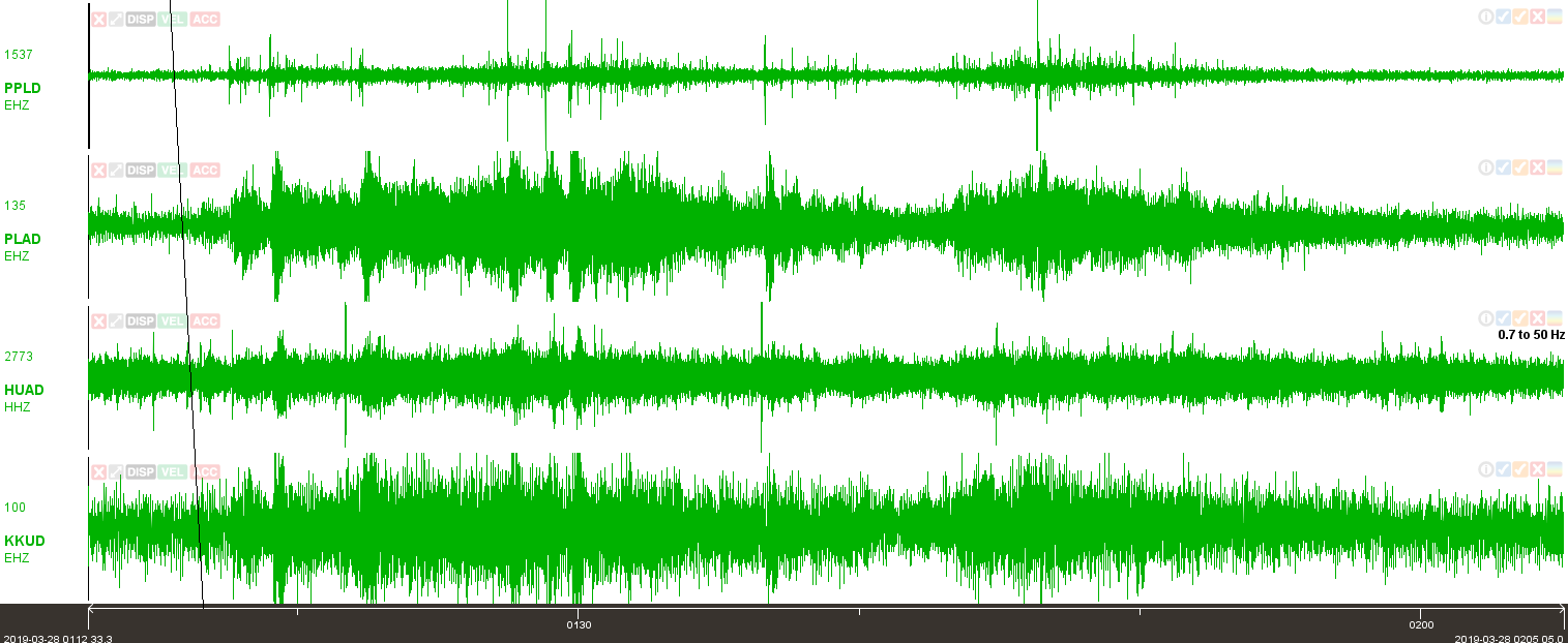 And here we have the 3rd event which started at about 1:16UTC March 28, 2019 and surprisingly lasted almost 43 minutes! I believe this event was smaller than the first one in this post, however it lasted almost double the time. The four green seismograms above are shown in greater detail via the 3-plots shown in the slideshow below: Additional information or data: So, wasn't that crazy? These events are extremely peculiar and I have never seen them occur anywhere else other than Hawaii. It is interesting to note that these events are somewhat similar to the Pu'u O'o seismic signatures that were detected when the crater collapsed. If you wish to see some quick plots of those, please CLICK HERE. Below I have selected 11 random stations from across the Big Island of Hawaii. Please note the following webicorders were NOT generated by myself, but were generated by USGS and the HVO. Please visit volcanoes.usgs.gov, select the volcano you want, and check out the seismic data via their webicorders. Webicorders are not in any way meant to aid you in analyzing events. However they do come in handy once in a while. Use the arrows in the top right corner of the slideshow below to quickly scroll through the 11 webicorders. Times should be matched up so, if you do it fast enough, you can see how these events traveled very far to distant stations. If you wish to see the locations of every seismic station in the HV network for Hawaii, then please CLICK HERE. Webicorders from across Hawaii which show these strange events (for some reason, the helicorders are terrible in slideshow format; email me if you wish to retrieve the actual images): Below I will show a very quick video. The video below contains the seismic audio to the largest "Other Event" that occurred today, March 27, 2019, and the seismic audio to the first "Other Event" I ever detected, which occurred on January 23, 2019. Remember, seismic stations do not have a microphone attached. Seismic audio simply generates seismic data in audible frequencies humans can hear. Everything is accurate, except for time. For example, the first event shown/heard in the video below is actually around 25 minutes long. However, in order to actually hear the event, it had to be sped up. Obtaining seismic audio from any seismic station, for any seismic event or swarm, is extremely easy. The IRIS Time Series URL builder can aid you in doing this. Either shoot me an email or check out the "...DOWNLOAD SEISMIC DATA" page under the "HOW TO..." dropdown menu... Either watch it below or CLICK HERE to watch the video on my YouTube channel. Headphones are highly suggested:
6 Comments
Paul Haugan
3/28/2019 07:35:06 pm
Sounds like magma intruding into water filled lava tubes.
Michelle
3/30/2019 05:04:00 am
It sounds like magma intrusion for sure. As Bill said could be the magma forming new dikes or working its way through older ones. Very interesting sound for sure. New submarine volcanoes could be forming too. There were submarine eruptions off the coasts of Kauai and Oahu in the 1950s-1960s causing water discoloration and pumice rafts. It will be interesting to see what happens next.
Ben
4/5/2019 12:27:14 pm
Michelle - Yes, that is likely. There are literally hundreds of submarine volcanoes off the shore of Hawaii in literally every direction. We are all watching and waiting to see what happens next! Very exciting! Well, until lava destroys homes or injures people. Then it becomes a problem. God bless!
Ben
4/5/2019 12:25:04 pm
Paul Haugan - Yes, it is likely this is definitely some type of magma either intruding or extruding. Actually it could be both. Sometimes the events get shallower with time, possibly showing intrusion, and they sometimes become deeper with time, possibly showing the extrusion of that same magma.They are still happening, though in a diminished form. However I bet they will return very soon.
Mindreaderphx
3/30/2019 02:04:19 pm
Snap, Crackle and Pop!!!
Ben
4/5/2019 12:28:21 pm
Yup, that is my assumption as well. They are pretty interesting and I still have not found them anywhere else. To the best of my knowledge, these only occur under Hawaii. God bless! Leave a Reply. |
About
This blog is specifically for activity that occurs in Hawaii. In light of 2018's eruptions on the Big Island, I felt it necessary to have a section entirely devoted to events in Hawaii. I now mostly use this blog to update people on volcanic spasmodic tremor which occurs deep within the mantle plume conduit(s) under Pahala, HI. Don't know what spasmodic tremor is? Don't fret! Simply go to the Hawaii menu and click the page about Hawaii Spasmodic Tremor. Archives
February 2020
Categories |
 RSS Feed